by Gordon Harris
A remnant of our Colonial roots in Massachusetts is the word “Commonwealth,” the principle that a political community must act for the common good, with power vested in the citizenry. This ideal was reflected in Puritan self-government for the sixty-three years of its existence.
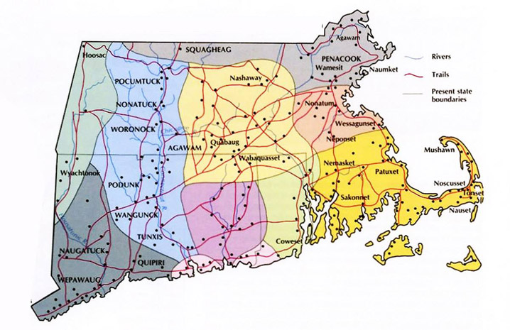
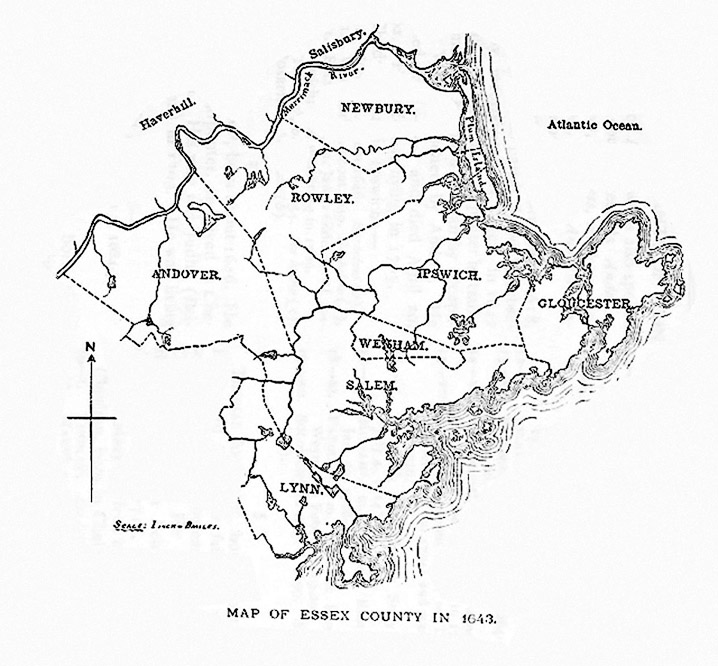
When the first Puritan colonists arrived here in 1626, the land, lakes, and rivers in our area were collectively owned by the Indigenous family group known as the Agawam people. With the exception of burning fields to plant corn, tribes relied solely on the seasonal but bountiful produce of the land, rivers, and ocean. The Native Americans were unfamiliar with the English concept of land ownership when in 1634, John Winthrop Jr. purchased all of the traditional Agawam land, stretching from Salem to the Merrimack River from the sachem Masconomet for the sum of £20.
Founded as a trading company, the Massachusetts Bay Colony was self-governing, treating its charter as if it were the constitution of an independent state. The Massachusetts Bay Company was set up as a joint stock venture. Any man contributing £50 to the venture was promised 200 acres of land. By 1642 the town of Ipswich and the general court handed out 9000 acres of land, leaving 3000 acres in the common pastures and 7000 acres ungranted.
In the commons, the early Massachusetts towns adopted English institutions of land management that often predated their own experiences in the mother country, reproducing medieval systems whose roots dated back several centuries. Shares of the Commons were granted, sold, and willed by freeholders, while newcomers to the towns were increasingly barred. Disagreements over usage and division of the common lands consumed the business of the towns, which responded with increasingly stringent measures to establish rules and enforce conformity.

During the Great Puritan Migration, Essex County was colonized by people from different regions of England who did not share a universally accepted concept of land ownership. Two major systems of pastoral land management existed in England in the 17th century. Settlers from central and northern England were still accustomed to manorial control over hundreds of acres for use by tenants who lived in the nucleated village. Shown above is an illustration of a manorial system with open fields where serfs farmed slender lots.

The brief Puritan experiment in Massachusetts reproduced the names of English towns, and a hybrid model of medieval land tenure, granting huge farms to the favored and elite immigrants while allocating small house lots to ordinary people, who received tillage and animal husbandry privileges in the large fields beyond the Common Fence that surrounded the settlements. Individually owned land was treated as capital, as it is today, but common land was shared and used, not owned. Cattle and other animals of a given community grazed on portions of the arable land that were not currently bearing crops. The privileges of cutting wood in the commons, harvesting hay, and damming the rivers were strictly controlled by the towns.
Titles of Respect and Ownership
- Mr. or Master: the highest-ranking man. Their wives were addressed as Mrs. or Mistress.
- Freeman: Men who had taken the freemen’s oath.
- Goodman: Men who had no other titles. A goodwoman, or “Goody” was the wife of a goodman.
- Freeholder: a man who owned land.
- Yeomen: one who owns and cultivates land (farmer).
- Commoner: a person with rights to the common
Outsiders
In the first year of its settlement, the freemen of Ipswich established “for our own peace and comfort” the exclusive right to determine the privileges of citizenship in the new community, and gave formal notice that “no stranger coming among us” could reside, even temporarily, without their permission. The towns were further able to weed out undesirables by denying them commonage. Inhabitants who had a share in the common pastures sought to limit further distributions of rights to the commons. In 1659 the General Court ruled that no house erected after that year would have any right to common lands without the express consent of the towns, and authorized the towns to demolish and remove the dwellings of unapproved persons.
Great Neck
Before the arrival of the Puritans, William Jeffrey held the right to use a coastal drumlin in Ipswich which today bears his name as a fishing stage. Because he was not a member of the Puritan community, the General Court paid him to leave, and in 1639, the town of Ipswich set aside all of Jeffreys Neck as a common pasture. In the 1650s, the towns of Ipswich and Newbury intentionally developed their sheep industries, with mandated workforces of shepherds and wool spinners. By 1662, there were four hundred sheep on Great Neck, which came to be called the “Ram Pasture.” The common fields on the south side of Ipswich became so burdened with sheep that a hundred were transferred to the north side of town to graze with the cattle. In 1702 the common lands were divided into large sheep pastures. Keeping cattle and sheep on the Necks and the hills surrounding the town continued into the early 20th Century.
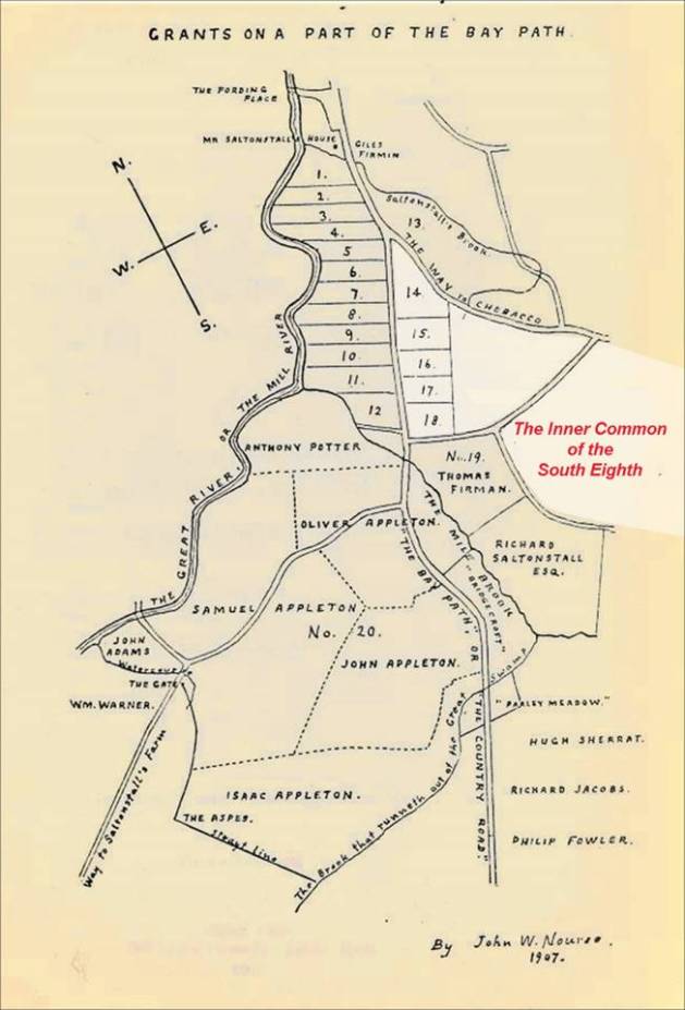
The “Inner Common of the South Eighth”
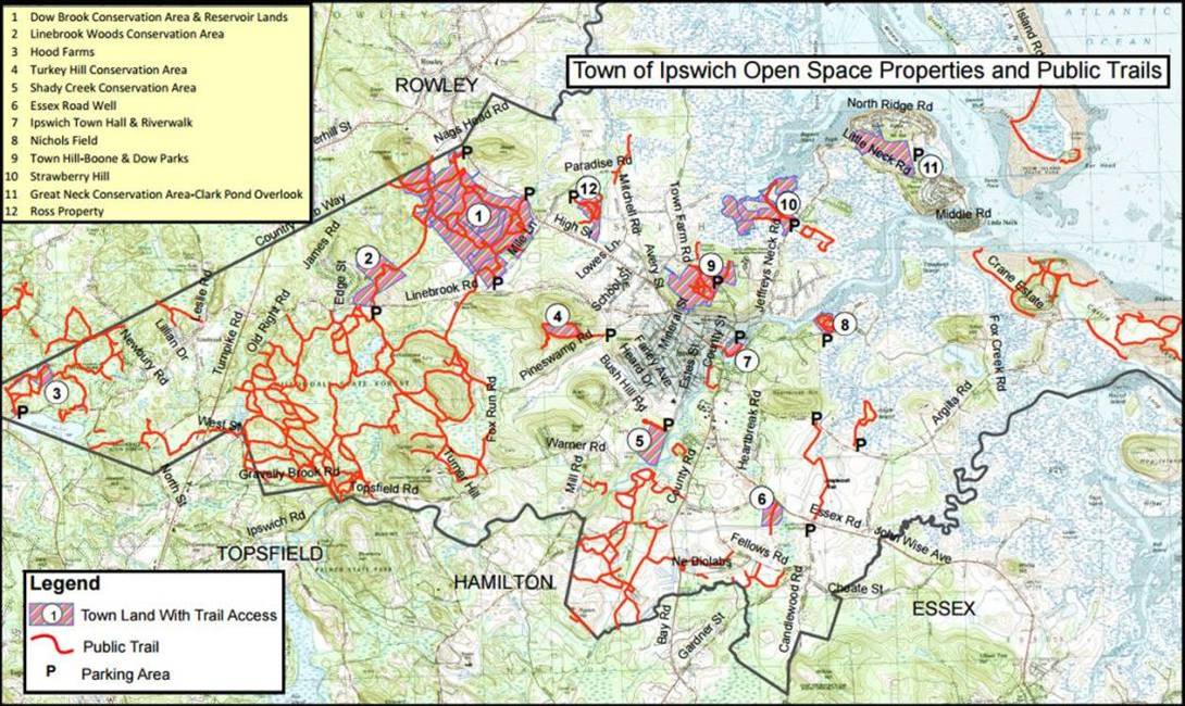
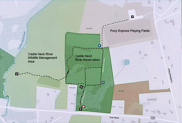
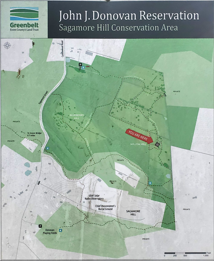
South of the Ipswich River was today’s South Green where cattle were herded in the mornings to the Heartbreak Hill common pasture, or further south to the Wilderness Hill common which is today’s Donovan Reservation. The area bounded by County Road, Essex Road, Candlewood Road, Fellows Lane, and Lakeman’s Lane was a part of the common land of Ipswich. When the common lands were divided into eighths in 1709, this area became known as the South Eighth. It included Gould’s Pasture, Ringe’s Pasture, Walker’s Island, and a pasture known as the Inner Common of the South Eighth.
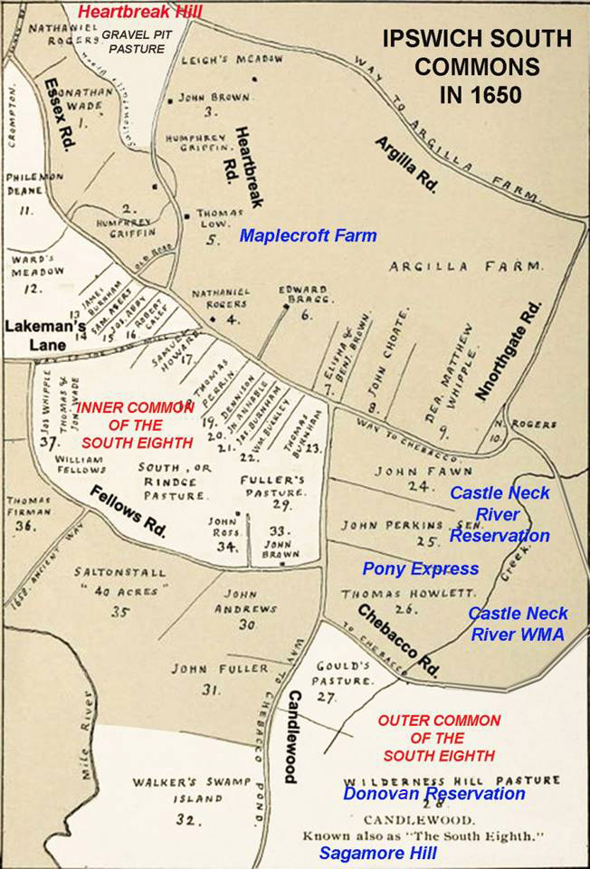
Today’s Argilla Farm and Maplecroft Farm are part of the huge farm that was granted to John Winthrop Jr. The land shown in white in this illustration was common land in what was known as the South Eighth. Greenbelt’s Donovan Reservation and Sagamore Hill in Hamilton were once part of the Ipswich South Eight Commons.
The rich soil on the south side of town also produced a scattering of large elite family farms in Candlewood and Chebacco. Appleton Farms remains the oldest continuously operating farm in America. Unapproved private enclosure of fields on the south side of town became a frequent issue of contention, and in 1649 the Town ordered the “restraint of inner fences.” The gentlemen farmers, the Symonds, Denisons, Hubbards, Whipples, Fellows, and Appletons, practiced individual agricultural ownership and management, and by the 1650s were no longer participating in communally managed herds. Established in 1638, Appleton Farms is one of the oldest continuously operating farms in America.
Topsfield

Topsfield, which was formed from parts of Salem and Ipswich, was initially granted in large parcels as reimbursements to wealthy supporters of the colony. In 1643 the Court granted Misters Endecott, Bradstreet, Symonds, Whittingham, Paine, and others of Ipswich and Salem the liberty to settle a village. The wealthy proprietors divided their lands and induced individuals, many of whom had settled first in Ipswich, to purchase parcels, recovering far more than their initial investments. A list of 31 commoners was recorded in 1661, and over the next 60 years in three separate divisions, the Topsfield common land was divided among themselves or their descendants by inheritance. Several proprietors acquired large farms by receiving abutting shares three times.
At about the same time, the Town of Ipswich expanded the grazing fields to the hills along Topsfield Rd. On March 15, 1651, complaints were made to the Ipswich selectmen “that the inhabitants of Topsfield do with their cattle feed on our cow common to the great prejudice of the Town herd.” They replied that if any of their cattle were found “feeding upon the cow commons of Ipswich, they shall be acknowledged to be trespassers, and the owners of them bound to make satisfaction.”
Fences
When the settlers arrived, many of the hills had already been cleared by the Indians, and the felling of trees was of great concern from the start. In 1639 it was decreed, “No man shall fell any timber without leave from the Constable, under penalty.” A special license from the Selectmen was required before any white oak could be felled on any house lot or in the commons. The felling of timber on Jeffrey’s Neck, Castle Neck, and Hog Island was prohibited in 1650.
In Ipswich, every man who built and owned a house became forthwith a commoner and had rights in the common land. Tillage lots of about six acres of commonage were assigned to each householder, and a fence separated them from the “Great Cow Common.”
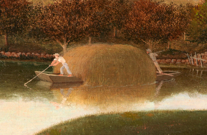
Residents who owned privileges in the common were to maintain the fence in proportion to their allotments. The town of Ipswich voted in 1637 that “a general fence shall be made” extending from the west end of the town to the Egypt River (today’s Rowley River), from the east end of the town on the way to Jeffries Neck, and on the south side of town from Heartbreak Hill to County Rd. Every morning great herds of cattle were driven out to forage in the woods. Men known for sobriety and carefulness were chosen for the important role of fence viewers. Originally, only grazing was allowed outside the common fence until the privilege of planting crops on Great Neck was granted in return for planting hay, a successful experiment that resulted in tillage privileges being granted throughout the commons.
Newbury

In 1635, the Rev. Thomas Parker led a group of about 100 pioneers from Wiltshire and Hampshire in southern England to found the town of Newbury. House lots, planting lots, marsh lots, and meadow lots were granted and laid out, and a quarter of the freemen of Ipswich decided to move and join their settlement. A house lot of four acres, with the right of pasturage, was assigned to the poorest settlers. Fifty acres were allotted to any persons who paid for their own transportation to New England. Two hundred acres were granted to every family that contributed fifty pounds to the common stock. The tiny settlement on the Parker River was surrounded on three sides by 3800 acres of salt marsh, and in 1645, the entire town relocated north to the Merrimack River to take advantage of more arable land. They maintained an open field at their earlier location, known historically as the Old Town Pasture where cattle grazed.

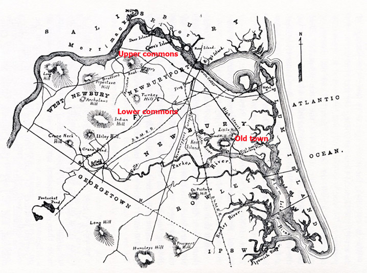
The Newbury Upper Commons included most of the land now in West Newbury, extending from the Artichoke north to the Merrimack River, and were used primarily for milk cows and other livestock in active use.
The Lower Commons was in today’s Newbury, south to the Rowley line, excluding over 2000 acres granted to Richard Dummer, Henry Sewall, and others at Newbury Falls, now called Byfield Parish. The two commons together comprised about 8000 acres. In 1641 the Newbury freeholders voted to divide the common lands closest to the village into three equally divided separate pasture areas, the cow common, the ox common and the heifer common, and the cattle were divided accordingly. For eight months of the year, the herd grazed during the day and was brought to the village common at night by the herdsman.

The freeholders of Newbury ordered, “that fences shall be made and always kept so sufficient as to keep out all manner of swine and other cattle great or small.” An order in 1653 required freeholders to maintain the fences in good order,” made of pales well nailed, or of five rails well fitted, or of stone 3½ feet high minimal, or a ditch 3-4 ft. deep with two rails, on penalty of a fine.” During the winter, the fence rails were knocked down, and horses and cattle were allowed to run at large in the commons and on Plum Island, where ditches were dug to drain the marsh for the ease of cattle.
Stints

All land owners were entitled by grant, purchase, or inheritance to own shares in the common and undivided lands, and operated the affairs of the Commons as an independent body of freeholders. Not all commoners were freemen; only those who had taken the freeman’s oath were allowed to vote in the town’s affairs. Five hundred and sixty-three stints in each Newbury pasture were divided among the freeholders in proportion to the number of shares owned by each.
Stints, often called cattle gates, were used in medieval open field systems to balance the number of stock animals with the capacity of the land and prevent overgrazing. In Newbury, Richard Dummer, despite owning a farm, received 62 stints, while the two poorest men received only one. In 1642, the freeholders of the town decreed that the number of stints they had allocated the previous year “shall perpetually belong to the several persons to whom they are allotted and to no other persons whatsoever, except he gets them by purchase or some other legal way.”
Rowley

In 1638 parts of Newbury and Ipswich were granted to Rev. Ezekiel Rogers, who led a group of immigrants from Yorkshire in northwestern England who were still familiar with an open field system. The farmers along upper High St. in Ipswich shared a close geographical and social relationship with Rowley and tended to stay longer with communally managed agriculture.
In 1649, The General Court decreed, “Upon the petition of Newbury, this court gives and grants Plum Island to Ipswich, Rowley & Newbury, with Ipswich to have two parts, Newbury two parts, and Rowley to have one-fifth part.”


In 1643 it was ordered, “that all the commons which belong to the town of Rowley, shall extend five miles from the town every way, where the town has property, which shall not be laid out to any particular person. It was agreed that every 1 1/2 acre house lot would have 1 1/2 gates in the common pastures. The apportionment rose exponentially so that a 6-acre house lot would have 45 gates. The use of the term gates instead of stints is another indication of how the settlers of Rowley had different open-field traditions. Records from the Probate and Quarterly Courts indicate that the commoners of Rowley had their own gates, instead of the common gates that were used in other towns. The town had authority to order any man to work in the common, and refusal to do so would result in a fine for every hour that he failed to appear.
Conversely, Ipswich adopted a principle of one house lot receiving one commonage, and in 1641 the freemen of the town voted that the Selectmen should no longer “meddle with further stinting of the common.”

Salt Marshes
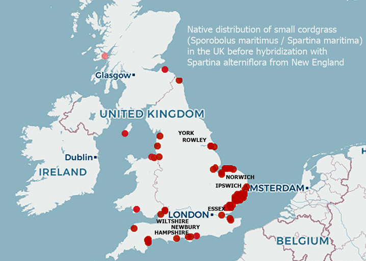
The settlers in Ipswich and Newbury, and to a lesser extent Rowley, came from coastal areas of England and were familiar with small cordgrass, traditionally known as Spartina maritima, which is the only salt marsh cordgrass native to England. It took years to cultivate English hay, but the native salt hay Spartina alterniflora (aka Sporobolus alterniflorus) was already here for the taking. Over the years, a hybrid of American Spartina alterniflora with the native English cordgrass has become dominant in the U.K., while the delicate Spartina pattens which is eaten by cattle became highly invasive in the Mediterranean and the American West Coast.
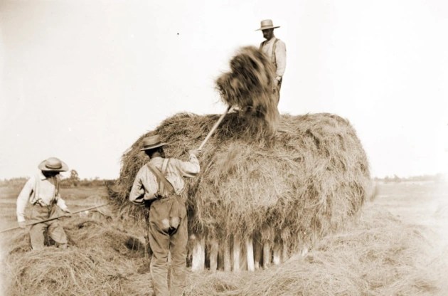
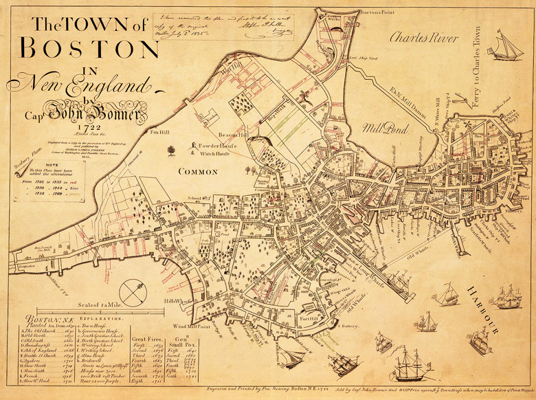
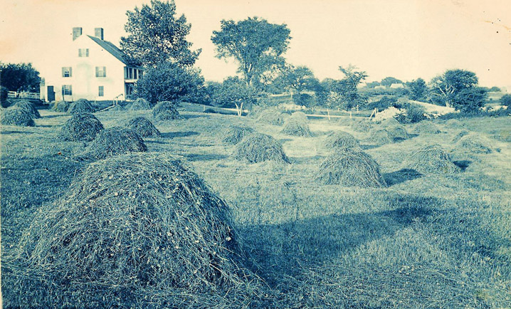
Marsh hay was harvested and shipped to the larger communities, including Boston where it was unloaded at Haymarket Square. A load of salt hay and thatch could be sold for a considerable sum, and the privilege of harvesting it was sold or auctioned annually by the towns. For over 200 years, the seasonal harvest of salt hay on Plum Island was a communal ritual, of cutting, stacking, and transporting the hay.
Trouble with Cattle
The records of the Quarterly Courts are replete with violations of the common regarding cattle:
In 1645, Thomas Tuck charged that “Richard Moore made a well upon the common for his own use the last summer, being very dry and water scarce upon the Neck. Tuck hired a cow, which came to drink at the well, and the water being very low the cow broke her neck.”
In the case of William Sargent v. Samuel Bushwell in 1653, for a cow “that was killed by a beast belonging to the defendant. Agreed that the plaintiff shall have half the price of the living cow and that the hide of the dead cow as appraised by town men shall be divided between them”
In 1655, John Devorex sued Samuel Yew, “For killing his cow by the falling of a tree in the commons.”
In 1662, in the case of Samuell Plumer vs. Charles Brown for trespass and taking up a heifer of his from Newbury Neck, John Hopington deposed that two years ago last Michaelmas, Charles Brown lost a black heifer, and at the same time there was a beast killed at a place called “the straits as we go to the rye field.” He heard Browne’s wife say that she feared it was their heifer. Thomas Hale Jr. deposed that the heifer came of a black cow which he sold to brother Lambert and that she was a very poor calf. He put her in the Rowley dry herd and she had the same ear-mark as his other cattle. Andrew Heddan testified that after the heifer was put into the dry herd, he told Charles Brown’s wife that he saw the cow in Rowley Common field upon John Harris’s ground and that at midsummer this heifer left the dry herd, came to the town and went with the cow herd, keeping constantly about Charles Brown’s yard.
In Ipswich Quarterly court, July 22, 1664, Daniel Black filed a complaint against his wife Faith, for keeping company with Judith Trumbull and John How, and sometimes being in bed with John How, and that he was a poor man and had nothing to live by but his labor and one cow, and for the want of the miking of the cow, he lost the profit because of his wife’s carelessness, by which he was provoked several times, often threatening her. John How testified that he heard Daniel Black “wish to God to damn his soul if he did not beat his wife’s brains out.”
Managing disputes like this was a burden to the selectmen. On May 7, 1659, the selectmen of Rowley ordered, “considering the great oppression of the cow commons by horses, mares, yearling colts and dry cattle that are not driven into the dry herd commons; that all inhabitants having more than one horse or mare shall drive their yearling colts and dry cattle into the dry herd commons within three days after the publication hereof upon penalty of 5s. The selectmen of Newbury ordered, May 14, 1663, “that all the dry cattle, except working oxen and yearlings, shall be driven up out of the cow commons.”
Dissension in the Commons
From the earliest times, there was resentment in Ipswich that some commoners weren’t fulfilling their obligations. Furthermore, it was complained that cattle from Newbury were tramping down the salt hay and it “would be the ruin and utter destruction of the whole island.” The division of the commons in Ipswich began in 1664 when the town voted that Plum Island, Hog Island, and Castle Neck be divided among the 203 inhabitants who had the right of commonage. Eight-acre lots of valuable salt marsh were provided to the 28 wealthiest men, while the poorer men received four, primarily in the upland lots. Adjustments were made for those who had been overlooked or “fell short of their due proportion” and for many years the town continued to issue corrections.

The Ipswich committee reported in April 1665 that there were 800 acres of marsh and upland on Plum Island, “beside beaches and gall’d hills.” Thatch banks and clam flats remained the property of the town and were let each year to the highest bidder, with only commoners having the right to bid. Hogs, horses, and cattle were kept on the island during the winter, ruining the marsh grass, and in 1739 the General court banned the practice. Today’s protected salt marshes and clam flats, with strict control of shellfish permits, are vestiges of preservation measures taken in the 17th and 18th centuries.
Restrictions on the number of freeholders were decreed in several towns but became problematic to enforce as the population grew. In 1660, individual lot grants were given in the Newbury and Ipswich Commons under the condition that the recipients would clear the land, fence it, and plant at least 4 bushels of English hay per acre. At the end of six years, the land would revert to being a common field. In this regard, land was intrinsically tied to its use rather than outright ownership, a concept shared by the indigenous people of America and in medieval England.
Division of the Newbury Commons

In 1683 the whole of the Newbury Lower Commons was divided into five “sheep walks.” Historian Joshua Coffin estimated a total of over 5,000 sheep grazed the pastures. At this time much of the land above the Artichoke River was still common, unfenced, and unimproved, although large quantities of lumber were being taken.
In the late 17th Century, the Newbury commoners became increasingly alarmed that their hereditary advantage was disappearing. At a meeting of the freemen and freeholders in 1684, it was voted that 6000 acres of the Upper Common would be lotted out, with only 1000 acres going to non-freeholders, and that “this shall not be a precedent to the future in the ordering or dividing of any other part of the common.” The total number of freeholders was based on the 1642 vote of 91 freeholders “and no one else.” The non-freeholders objected that they paid the same taxes as freeholders and should have the same rights. In 1686 the allocation was altered, with half going to freeholders, and the other half going to other freemen who were up to date on their taxes. Those who paid more in taxes received larger shares, with the locations of the allocations determined by drawing names out of a bag.

In January 1701, the freeholders of Newbury voted to divide the majority of the Lower Common, comprising 1,800 acres, while reserving pasturage for the town’s ministers and free school as well as for the benefit of the town’s poor. The wood remaining on the common land was measured and divided among the freeholders and inhabitants in 1701 and again in 1708.

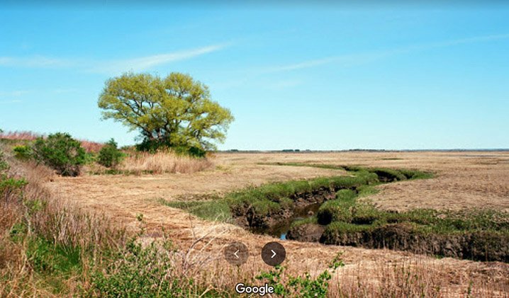
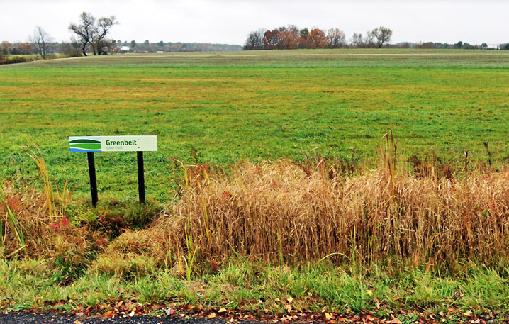
The 47-acre Wet Meadows conservation area on Scotland Rd. in Newbury. Image courtesy Essex County Greenbelt
The marshes on Plum Island were for many years retained by the commoners. Ditches were dug to drain the marsh for cattle, and later to mark individual lot boundaries. Finally, at a meeting of the proprietors of the Newbury common lands held in 1827, the standing committee was instructed to sell at public auction “all the lands belonging to the said Proprietors in the town of Newbury, and conveyed for the sum of six hundred dollars to Moses Pettingell, of Newbury, “that part of Plum Island lying & situate in said town of Newbury, containing twelve hundred acres, more or less.”

Pettingell made a tidy profit from the sale of Plum Island’s timber and sand, and the size of his holdings grew unexpectedly when the Merrimack River channel shifted to the north in the mid-19th Century. In 1920 the Plum Island Beach Company purchased the Newbury section of Plum Island from the Pettingell family, constructed Northern Blvd, and divided the land into lots for sale to the public.
Division of the Ipswich Commons
In 1660, the Ipswich Selectmen petitioned the General Court that the town had become burdened by the multiplying of dwelling houses. The Court ordered that no house henceforth erected shall have any right to the common lands and applied it to all towns, which responded by drawing up two lists, one of the number of original commoners, and a second of whom among them still had rights to the common. Those who had moved to their farms would no longer have commonage. A pressing issue was that wealthy farmers who already had commonage were passing their farms to their sons and retiring to their houses in town, a threat to the “one man one commonage” rule. Did commonage belong to the individual or could it be transferred along with sales of property?

Resolving continuous disputes regarding cattle and sheep was burdensome for the Ipswich Selectmen, and as the 17th Century ended, men began boldly asserting sovereignty over their allotments. The scarcity of new productive land to expand the commons system convinced the towns’ leaders as well as the proprietors that the common fields should be distributed permanently.
In 1709, a list of old and new commoners was agreed on, and the remaining 5850 acres of common land, about 9 square miles of common lands were divided into eight parts with two-fifths going to descendants of the original settlers and three-fifths to more recent commoners. Three further divisions occurred, the last being in 1720, including 900 acres in Chebacco, which is now the Town of Essex. The land could now be rented or sold. Price controls were attempted but several men became rich investing in commonage.

After the Revolutionary War, the State of Massachusetts enacted various measures regarding commons, setting rules for meetings, fencing, taxing, and trespassing, in an attempt to stabilize the Commons system. Finally, in 1788, the majority of the Ipswich commoners voted to resign all their interests in the remaining common lands toward the payment of the heavy town debt incurred during the Revolution, a grant estimated to be worth about £600.


Division of the Rowley Commons

In 1673-4, almost a decade after Ipswich and Newbury began dividing out their commons, it was agreed by the town of Rowley that two-thirds of their town commons should be divided out to the proprietors in proportion to the number of gates they owned. Unimproved remnants of the common fields persisted into the 18th Century. In the 1794 Plan of the Town of Rowley, the publisher noted that “there are large tracts of barren and unimprovable land whose owners determine that they are not worth fencing. Some of these lands are marked in yellow.”
Threats to Deeds of Ownership

In 1622, eight years before the establishment of the Massachusetts Bay Colony, Capt. John Mason had obtained title to all the land from Salem to Newburyport as a principal partner in a stock company known as the Plymouth Council for New England. In 1681, his grandson John T. Mason presented a letter from the King to the General Court, which ordered “all said tenants” to appear in the Ipswich court. If his birthright claim was confirmed, every land title would be worthless and Mason would have been able to impose a medieval manor and tenant land system. Eventually, his case failed, after causing extreme anguish among the populace.

Then in 1686, Governor Andros imposed a 2.5 shilling quit rent per annum on all 100-acre lots not occupied, or occupied with defective titles. Since all of the existing land titles in Massachusetts had been granted under the vacated colonial charter, Andros essentially declared them void and required landowners to recertify their ownership by paying fees to the Dominion as a quit-rent. To strengthen their title, the Selectmen of Newbury, in consideration of £10 purchased the entire town of Newbury from Samuel English, the surviving heir of Masconomet, constituting about 10,000 acres. The threat ended when news reached Boston of the overthrow of King James II, and Andros was arrested by a mob that descended on the city.
Further Afield
Each town developed its own standards for allocations and divisions. In Salisbury, the lot that one received was based on what he was worth. The settlers of Gloucester replicated their customs from western England, where fishing was the primary industry and enclosure was well advanced. In Haverhill, John Ward and his followers doled out 20-acre house lots to themselves, leaving common land mostly along its periphery, and by 1659 its open-field structure had disappeared.
Andover retained its open-field system longer than the older towns established by people from the east and south of England. Today’s North Andover was the center of the original town of Andover, MA. The common fields were in the south part of town, which is now the town of Andover. The Trustees of Reservations’ Ward Reservation is on land that was part of the common fields.
The Ipswich Commons Today
In the spring of 2000, the Ipswich Town meeting authorized a $10 million Open Space Bond for the protection of land for open space, water supply protection, and recreation, preserving the land from development. The town’s investment adds to Willowdale State Forest, Plum Island, Appleton Farms, and Crane Beach, which are preserved by the State and environmental organizations.


The Rowley Commons Today

The Newbury Commons Today

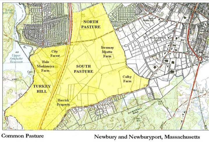
The Common Pasture located in Newbury, Newburyport, and West Newbury, is a remnant dating back to 1635. The entirety of the present-day Common extends from north of Hale Street in Newburyport, crosses Hale St. through the City to Turkey Hill Road in West Newbury, then follows Scotland Road in Newbury and abuts the Little River Nature Trails on the eastern branch of the Little River. The City of Newburyport, the Town of Newbury, the Trust for Public Land, Essex County Greenbelt Association, and the Parker River Clean Water Association have worked together to protect key portions of the Common Pasture through land acquisition and agricultural preservation restrictions.
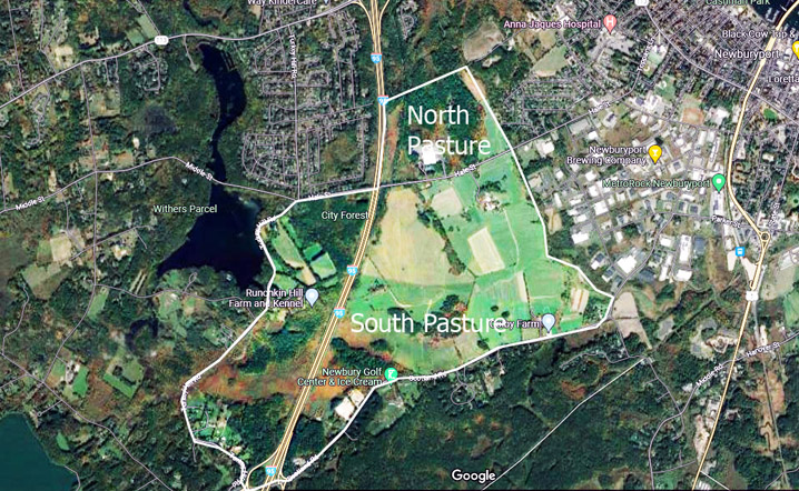
In 2006, the City of Newburyport and The Trust for Public Land (TPL) announced the acquisition and permanent protection of the 102-acre North Pasture property on Hale Street in Newburyport. The North Pasture today comprises about 240 acres, extending to the Little River. A trail system winds through the Cooper North Pasture. The South Pasture area is zoned agricultural/residential and contains the largest concentration of farms remaining in Newburyport. Scotland Road delineates the southern boundary of the South Pasture. The land along the south side of Hale Street from Route 95 east to the Little River comprises the northern portion of the South Pasture. The Turkey Hill area includes land west of Route 95 that was historically part of the lower common in Newburyport and West Newbury.
Further reading:
- Waters, Thomas F., “Ipswich in the Massachusetts Bay Colony”, Volume I, Chapter 6
- Perzel, Edward S., “Landholding in Ipswich,” Essex Institute Historical Collections, October 1968
- The transplantation and transformation of the English shire in Essex County, Massachusetts, 1630-1768 by Harold Arthur Pinkham Jr.
- Wideman, Bernard: “In English Ways,” Ipswich Chronicle 1984
- Community Custom and the Common Law: Social Change and the Development of Land Law in Seventeenth-Century Massachusetts by David Thomas Konig
- From Common Land to Public Space: The Frog Pond and Mall at Newburyport, Massachusetts, 1765-1825
- Commons and Enclosure in the Colonization of North America by Allan Greer
- The Challenge of the Commons: Beyond Trespass and Necessity by Monica E. Eppinger
- Retrospectives: Tragedy of the Commons after 50 Years by Brett M. Frischmann, Alain Marciano and Giovanni Battista Ramello
- The Best Title That Indians Can Claime”: Native Agency and Consent in the Transferal of Penacook-Pawtucket Land in the Seventeenth Century by Peter S. Leavenworth, The New England Quarterly Vol. 72, No. 2 (June 1999)
- Changes in the Land: Bounding the Land by Madison Public Schools
- Cronon, William: Changes in the Land, Indians, Colonists, and the Ecology of New England
- The Rural Demography of Medieval England by Charles Ackerman
- Historic England: Field Systems
- The form, function. and evolution of irregular field systems in Suffolk, c. 1300 to c. 1550 by Mark Bailey
- Crotchets of Division by Alison Vannah
- Wikipedia: Common Land
- Stints and sustainability: managing stock levels on common land in England, c.1600–2006, by Angus J. L. Winchester and Eleanor A. Straughton
- A Short History of Enclosure in Britain, The Land magazine
- Puritan village; the formation of a New England town by Powell, Sumner Chilton, 1924-
- The story of Byfield, a New England parish by Ewell, John Louis, 1840-1910
- The history of Rowley, anciently including Bradford, Boxford, and Georgetown, from the year 1639 to the present time – Gage, Thomas
- A sketch of the history of Newbury, Newburyport, and West Newbury, from 1635 to 1845, by Joshua Coffin
- History of Newbury, Mass 1635-1902 by John J. Currier
- The History of Topsfield by George Francis Dow
- Stints and sustainability: managing stock levels on common land in England, c.1600–2006 by Angus J. L. Winchester and Eleanor A. Straughton, The Agricultural History Review Vol. 58, No. 1 (2010)
- Allen, David Grayson, In English Ways, The Movement of Societies and the Transferal of English Local Law and Custom to Massachusetts Bay in the Seventeenth Century.
- Fischer, David Hacket: Albion’s Seed, Four British Folkways in America
- Commoners of Ipswich Book of Records 1720-1788, Ipswich Town Clerk’s office Box 13

Download Contention in the Commons as a PDF file
