Gordon Harris is a local historian living in Ipswich, Massachusetts, and publisher of the Historic Ipswich site. Follow him at https://www.linkedin.com/in/gordonrharris/
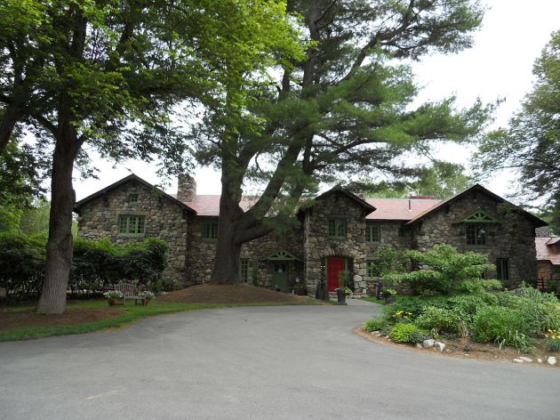
Sometime in the mid-18th century, Moses Newell Senior (1716-1795) moved from Roxbury to West Newbury and purchased land, which is now Newell Farm on Main Street. His wife was Sarah Gerrish. In 1846, his son, Colonel Moses Newell, built the 25-room house now standing at 243 Main St.
This house was originally on the Newell property and stood closer to the street, with a well next to it. In 1820, the Commonwealth of Massachusetts allowed a petition by Col. Moses Newell, son of the earlier Moses, to divide his land in Parsons, which was the first, brief name of West Newbury. In the same year, half of the original house was moved across the street, and is today’s 238 Main Street. In August 1853, this lot, with this house on it, was sold to William F. Loring by Col. Moses Newell. It is said that the other half of the old house had burned.
For several decades in the 20th century, this house was owned by Norman and Ruth Moore, who moved to Newbury from Greenfield in 1944. Mrs. Moore wrote that the house was being used for guests and hired help, and half of the house burned while it was still on the farm.
Although little of the original framing of the house can be observed, the three-bay front facade and single-bay side depth of the front portion of this house indicate construction during the early Georgian era.
180:13: (9-8-1804) John & Lydia Orgood, heirs of Moses Newell, sold land, with this house, to Joseph Newell, for $220, all of the property of Moses Newell Sr., who had died.
206:230 (4-20-1815). Sale of 13 acres by Isaac Short to Joseph Newell, followed immediately by sale a sale of the same, by Joseph Newell to Moses Newell.
224:51. (3-25-1820). The Commonwealth of Massachusetts allows Moses Newell’s petition to divide his land in the town of Parsons. (*On February 18, 1819, the General Court of Massachusetts passed an act “to incorporate the town of Parsons.” On June 14, 1820, the legislature passed another act to change the name to West Newbury.)
224:51. (6-3-1820). Col. Moses Newell petitioned for land partition on a different piece of property. This house was then brought across the street.
485:150-52: (8-1853) Moses Newell sold to William Loring, “a certain lot of land with the buildings thereon,” for $325.00, bordered by the highway, beginning at the easterly corner of land owned by Joseph Stiles, with land of Moses Newell northwest. In the following deed, Loring received a mortgage from Joseph T. Gordon for $350.
820: 20-21: (August 12, 1871). William & Jane J. Loring took out a mortgage on the same lot of land. Sold back to Moses Newell. Joseph T. Gordon acknowledged full payment of the mortgage.
Twentieth Century Deeds
1946:142-144: Elizabeth M. Newell paid $1.00 to Charles H. & Bessie M. Danforth (executors?) and took over William F. Loring’s mortgage. 12-1-1908
Book ?: page 741: (11-7-1966) George F. Briscoe & Judith A. Briscoe sold to Philip K & Eleanor R. Bragg.
3460: 534-525: (4-25-1946) M. Abbie Urie (widow) sold to Norman & Ruth Moore.
5040:132: George F. & Judith Briscoe bought from Norman C. & Ruth E. Moore, with a cesspool easement, 2-25-1963.
3263:332: Price and Smith to Edward L. and M. Abbie Urie.
3110: 16-17: Howard Atwood (trustee for Elizabeth M. Newell) sold to Marion N. Potter (4-23-1937).
The house at 39 Pleasant St. was built for Joseph Jewett in 1732. Ownership by Jewett heirs continued by inheritance and marriage through the Hale and Cressey surnames until 1947. The following information is from the MACRIS site of the Massachusetts Historical Commission:
ROW.46 Langley – Jewett – Hale – Cressey House 39 Pleasant St., 1732
“This 1732 half-house, with a two-story ell, has nine over six windows on the first floor and Indian shutters. The inside has many interesting features, such as large beams and curved, corner arched framing, which is exposed. There are few, if any, other houses exactly like it in the community of this period.
“This house sits on the two-acre house lot, which was granted to Robert Hunter, the first settler. He died in 1647. It passed through the families of Langley, Hale, and Cressey, all prominent families in town, who always lived on this street and built many of the early houses here. Langleys and Hales are no longer there, but the large market and flower garden farm of the Cressey family is still operating on nearby lots on this street, as it has, for nearly 200 years, provided employment for many young people in the town who are interested in market gardening.”
Robert Hunter
This house sits on the two-acre house lot, which was granted to Robert Hunter, an early settler, who died in 1647. His will mentions his wife, Mary, to have lifetime use of the house and lands; the remainder went to Abel Langley, “if he shall settle here & carry well towards his Dame”. Otherwise, the remainder of the house was to be for the use of the poor of Rowley. (Source)
Abel Langley
Abel Langley agreed to the terms and had possession of the land in 1654. His wife, Sarah, died on May 16, 1666. His second wife was Mary, daughter of Thomas Dickinson, who died on April 22, 1673. Langley’s third wife was Sarah, daughter of Mark Quilter of Ipswich, who died on June 20, 1683. Langley’s will was probated on June 10, 1687. He had a son also named Abell, or Abel.
In 1725, the Quilter and Langley heirs transferred part of the estate of Abel Langley to Joseph Jewett (61:239) in a lengthy deed that is difficult to read. In 1732, Abel Langley and Sarah Quilter, daughter of Samuel Langley and other heirs, sold this house lot to Joseph Jewett (61-239), and Joseph Jewett built this house. (Source: Early Settlers of Rowley). In 1741, Abel (aka Abell) Langley, son of Abel Sr., quitclaimed “land, marsh, and meadows” to Joseph Jewett’s heirs (83:77).
Joseph Jewett, the early settler of Rowley (1609-1660), was a distinguished, wealthy merchant. Captain Joseph Jewett, son of Joseph Jewett, served as representative to the General Court in 1718 and 1719.
Deacon George Jewett
Deacon George Jewett (John-Nehemiah-Nehemiah-Joseph-Edward) was born in Rowley on March 18, 1746-7. He married on April 16, 1771, Sarah Noyes of Ipswich. Sarah Noyes Jewett died in Rowley of consumption on Feb. 12, 1824, aged 76 years. Deacon George Jewett died on May 5, 1829, at age 83. Their children, born in Rowley, were:
Sarah, born Jan. 11, 1772.
Susannah, born June 5, 1775, married Pemberton Hale in 1797.
Hannah, born Oct. 25, 1774; died Oct. 12, 1800.
Lucy, born Aug. 2, 1776; died June 26, 1796.
Dolly, born June 26, 1779; died Feb. 26, 1798.
The Cressey Family
The year following Deacon George Jewett’s death, the 1830 Rowley map shows the owner of this lot as Nathaniel Cressey (1800-1875), who in 1823 married Sarah Jewett Cresey, the daughter of Pemberton Hale. Hale moved to Rowley from Newbury and married Susannah (Jewett) Hale in 1797. This house, and the land across the road, came into the possession of Pemberton Hale through his marriage to Susanna Jewett, and in 1823 became the home of Nathaniel and Sarah Cressey. A house on the north side of their lot was constructed by Daniel Hale, son of Pemberton Hale.
This house stayed in the Cressey family for over a century. In the 1884 map, the house was owned by George Cresssey. In 1947, the estate of Bertha L. Holbrook (nee Cressey) sold the “Old Place” to Joseph and Lucy Dubuque. (Deed 3560:560)
The 1830 map of Rowley shows Nathaniel Cressey as the owner of this house.
Architecture of 39 Pleasant St.
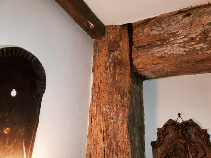
The Rowley assessors’ page provides a date of 1732 for the construction of this house, which is compatible with physical observations. The house at 39 Pleasant St. is a two-over-two “half house” constructed in the early Georgian era, and features 1″ thick Georgian / Federal through-tenon doors throughout the house. The front entry is typical of early half houses with a landing and a winder stairway. The front, original part of the house is three bays on the front side (one door and two windows) and a single bay (one window for a single room) on the side. The house is slightly deeper than First Period houses.
Originally, the house had a central chimney stack, which was later removed, and a smaller brick flue was installed as the chimney for the boiler in the basement. The back walls of the rooms on either side of the house have decorative fireplace mantels attached to plaster walls, with no indication of a previous fireplace. An ell on the rear of the house appears to have been added not long after the construction of the front of the house. On the wall facing the rear of the former central chimney is a very wide mantel, which is again attached to a plaster wall, indicating the probable early existence of a large cooking fireplace before the chimney was removed. These three phantom fireplace mantels are an enigma.
The 1872 Rowley map shows Nathaniel Cressey as the owner of the house. The configuration of the rear ell is quite different than today. On this map, Pleasant St. is labeled High Street.
The 1884 map of Rowley shows George Cressey as the owner of this property. The rear ell has the present configuration, minus the shed porch on the west side. The map shows a barn that no longer stands. George Cressey is also shown as the owner of today’s Cressey Farm.
This house originally stood on Summer Street in Rowley. One and a half acres were granted to Richard Wicom, an early settler of the town (whose son, Capt. Daniel Wicom, was Quartermaster in King Phillip’s War). In 1661, Richard Wicom willed it to John Wicom (2-199), and he, in 1683, sold it to John Pickard (5-39).
The Wicom family still owned lots in the former common lands. Daniel Wicom2, grandson of Richard Wicom, sold various properties before moving to Norwich, CT, in 1714, where he bought a farm. The last sale of the former Wicom wood lots and planting lots in Rowley was by Richard Wicom of Newbury in 1730.
After purchasing the property in 1683, the Pickard family owned it for over 100 years and enlarged or constructed this house. In 1797, Abigail, the widow of David Pickard, sold seven acres to Hannah Pearson, wife of Daniel Pearson and daughter of Joseph Nelson, for $1000, “bequeathed to me by my late husband (163 -24). In 1802, Hannah Pearson sold it to Solomon and Jacob Lowell, “blacksmiths.” Jacob and Mary Lowell, in 1804, sold five acres of the property to Lieut. Daniel Foster of Ipswich (185-24), who, the following year, built a house which he sold in 1809 to Moses Dole, and moved to Newburyport.
In 1812, Solomon and Moses Lowell sold the remaining two and 2/3 acres “with the buildings thereon” to Moses Palmer for $200.00 (195-218). These 2 &2/3 acres had originally been the house lot of Richard Wicom. Mr. Palmer sold it to John White (233-70), and in 1829, White sold it to Thomas Cressey (266-224). Mr. Cressey in 1836 sold the same 2 2/3 acres, with a dwelling house, barn, and two joined shops, to Peabody Dole (316-28) for $36.00.
The house is moved from Summer St. to Main St.
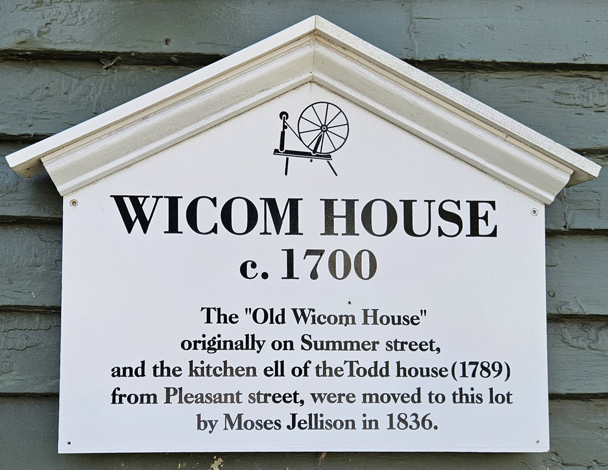
Peabody Dole sold the old house from the two & 2/3 acre former Wicom lot on Summer Street to Moses Jellison, who in 1844, purchased 3 1/2 acres on Main Street from Nathaniel Bradstreet (565-90). Joseph Dummer wrote that Jellison “bought the Wicomb house on Summer Street of Mr. Dole, and half of the Todd house on Pleasant Street and moved them to this lot” on Main Street (Rt. 1A). This was probably in 1845, the same year that the other half of the house was sold (see below). The section of the Todd house is still attached to the right rear of the combined structure at 155 Main Street.
Age of this House
The year in which this house was originally constructed on Summer Street is unknown. The inventory created by the Rowley Historical Commission on the MACRIS site gives an approximate date of construction as 1750, whereas the sign on the front of the house reads “c. 1700.” Structural observations suggest that the north end of the house was possibly constructed in the late 17th century. The south side was added by the Pickard family in the 18th century, although the historical records refer to it as the Wicom house.
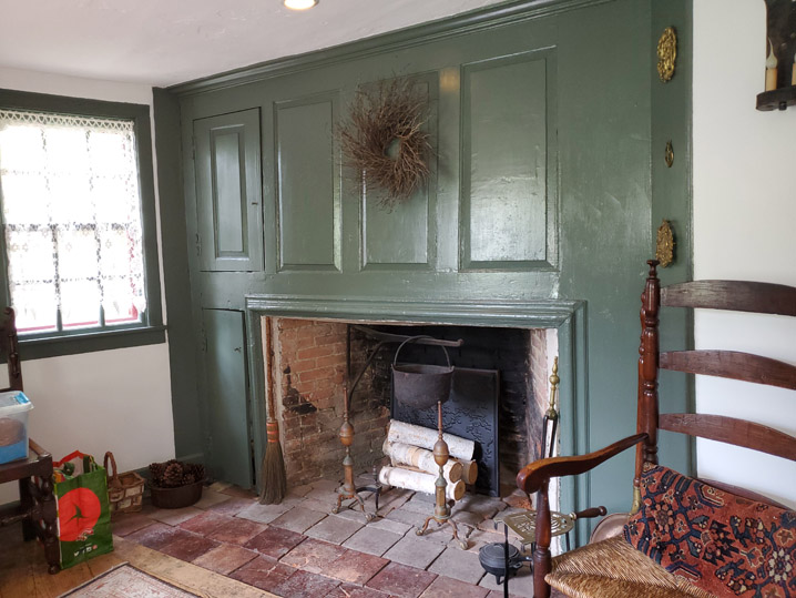
Rear view of the house. At some point in the early 19th century, the central chimney was removed and two Rumford fireplaces were incorporated into the rear walls of the house.
Structural Observations
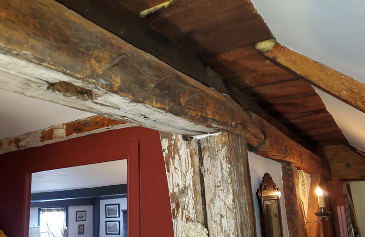
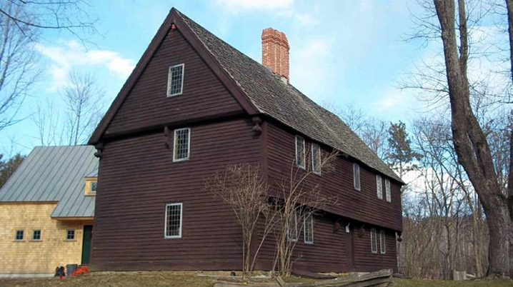
This house has a slightly asymmetrical front facade and single-bay depth for the main body of the house, with a later wing on the right rear that was moved from the Todd House. The “broken back” saltbox shed on the rear left is believed to have been added in the 20th century.
The left (north) side of the main body of the house appears to be somewhat older than the right side. The windows on the downstairs left are about 4″ higher than the right, albeit identical. The front entryway is shallow, typical of First Period and other early single-bay houses before 1725. The winder stairs are unusually wide for the depth of the house, extending into what was probably once the central chimney bay, which was replaced by Rumford fireplaces and twin chimneys in the rear wall of the front of the house. A third chimney is in the rear right wing that was moved from the Todd house and still serves as the kitchen.
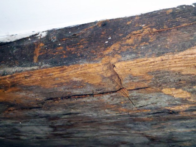
Summer beams in the front and upstairs rooms are wide and substantial, but are boxed, preventing observation of chamfers or decoration. Two summer beams in the basement and an unboxed beam in a closet have a 1″ chamfer. The exterior clapboards are each only about 3-4′ long, scarf-jointed, with less exposure on each board than usual. Short clapboards with scarf joints were used in the Colonial era, although the form persisted in some rural areas into the early 19th century. It is unclear when the existing clapboards were installed.
The roof doesn’t have rakes on the sides of the house. In the attic, new purlins were laid over the rafters, increasing the roof height by about 3-4″ to allow enough height for the front soffit, when the right side was added, or more likely, when the house was moved to its present location.
Subsequent History of 215 Main Street
In 1852, Moses Jellison sold the place to Charlotte Jellison (467-17), and she in 1855 sold the house and 1/2 acre to Nathan Todd (566-91), who in 1856 sold it to Daniel Morrison (567-91) Mr. Morrison in 1857 bought five acres of Joses Jellison (567-92). He also sold three acres in 1860 to Ezekiel Baley (614-65), who in the same year sold it to Frederick Bailey (614-66). Mr. Bailey in 1864 sold it to Oliver Blackington (715-171), who had bought in 1852, half of the house and 12 rods of land from Charles Cressey, the executor of the will of his father Richard Cressey, who had married Dorothy, daughter of Moses Bradstreet (302-227). In 1912, the heirs of Oliver Blackington sold 3/4 acres with the house to Loanda D. Pedrick (2171-239). She sold it to John N. Newell (2396-373) in 1918, and he sold it to Ernest C. Copper (2636-284) in 1925. In 1930, Copper sold it to Charles J. Henrich.
“Richard Wicom (aka Wickham, Wakam) had an acre and a half house lot in 1643. By deed, dated 26 June 1661, he gave his homestead and some other lands to his son John, in consideration of the support of himself and wife Ann, during life (Essex Deeds 2 Ips: 199). John Wicom sold this homestead in 1683 to John Pickard (Essex Deeds, 5 Ips. 39). He was buried 27 Jan. 1663-4. His widow, Ann, was buried on 25 August 1674. Their children were Daniel, born in England about 1635, who married Mary Smith; Thomas was buried 6 July 1660, and John, born about 1647, married Abigail Kimball.
“John2 born about 1647, married Abigail, daughter of Henry Kimball of Ipswich. He was living in Newbury on 5 September 1702. His homestead was near the present Dummer Academy (Governor’s Academy).” Other members of the Wicom family relocated to Connecticut, and the Wicom surname disappeared from Rowley history around the beginning of the 18th century.
“John1 Pickard, carpenter, son of Widow Ann Lume, married in 1644, Jane, daughter of Widow Constance Crosby. He was a representative in the General Court and prominent in the affairs of the town. He was buried on 24 September 1683. His will, dated 6 September, 1683 mentions, to wife (unnamed, “I give my now dwelling-house & buildings, orchards and Lands I live upon situate & Lying in the bounds of Rowley & Ipswich; also the Village Farm which Matthew Perry liveth upon with the privileges thereof all during the time of her natural life; also all my moveable estate to be at her dispose; always providing that my Dear wife be my sole executrix & that she receive all such Debts as are Due to me from any persons whatsoever.” To son John Pickard, what has already been given him and the farm at Johnson’s Pond, also the reversion of what has been given wife. To son Samuel Pickard, all the land between Samuel Dresser’s land and land of John Wicom, also the land on the other side of the street, of about four acres, also one-half of that land “I purchased of my son Thomas Hammond,” also after wife’s decease, the farm now in occupation of Matthew Perry….The inventory of his state, amounting to £1279, was taken on September 23. 1683. His widow, Jane, died February 22, 1715-16 age 89 years. His homestead in Rowley, from 1660, was in the “Morland” or “murlay” field.”
The year in which John Pickard Sr. died was the same year in which John Pickard (perhaps Jr.) purchased the house of Richard Wicom.
George Blodgette wrote in Early Settlers of Rowley, Massachusetts, “The house in which he died was on the site now (1932) occupied by the house of the late Daniel Harris Hale on Main Street. It may have been a part of the present house. The home farm extended easterly and southerly into Ipswich to include a large portion of Jewett’s Hill.”
The Todd House
Joseph Dummer wrote that Jellison bought the Wicomb house on Summer Street and half of the Todd house on Pleasant Street and moved them to this lot” on Main Street (Rt. 1A) after he purchased the lot in 1844. The Pleasant Street lot on which the Todd House originally sat was granted to James Bailey. In 1780, Hannah Bailey married Nelson Todd. Their son Henry Bailey Todd sold one-half of the house across the street, and a new house constructed in 1841, to Caleb Todd in 1845 (202-268). The other half of the house across the street was moved to 155 Main Street the same year.
Description from MACRIS
“ROW.51 Wicom, Daniel – Todd House 215 Main St r 1750: This 18th-century, two-story house, with lean-to and side porch, is one of the few of its kind in the town. The fact that the house was originally two separate houses on different streets in town, moved to this location at the same time, and incorporated into one house with such pleasing style, demonstrates the capabilities and engineering knowledge available among the settlers at that period in history.
“Several persons connected with the military once lived in this house, or in one half of it. Another was a blacksmith. All played equally important parts in the development of the community in their individual ways. Dan Wicom was listed as a carpenter. He was a direct descendant of Richard Wicom, one of the First Settlers. One half of this house was moved from the First Settler’s original lot on Summer Street. The other half of the house was moved from Pleasant Street and was called the Todd House. A part of the old meeting house was used in building the barn, which has since been taken down.”
Sign on the Wicom House
Present and past locations of sections of the Wicom House
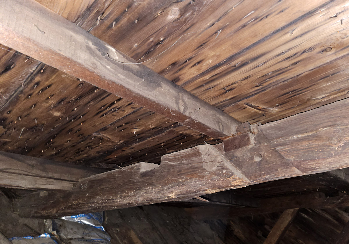
End rafter in the Wicom House. A new roof was added, and the older purlins were replaced.
Another rafter in the north end of the Wicom house showing how the old purlins were removed and new purlins were added on top of the rafters, which allowed the roof of the conjoined front sides of the house to have enough height for a cornice.
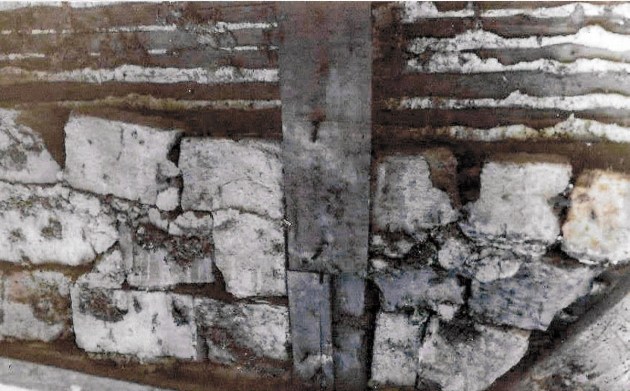
Brick fill in the left end of the Wicom House
When the present owner was replacing clapboards on the north end of the Wicom House, he discovered several rows of bricks inside the wall, some of which fell out. The above photograph shows the three remaining rows of irregular bricks, which inexplicably appear to have been whitewashed on the outside.
Architectural historian Abbott Lowell Cummings, author of The Framed Houses of Massachusetts Bay, wrote, “Common, if not universal, was the infilling of the frame with brick and clay. For those areas of the frame where the fill might be exposed within, for example, on top of the plate, the bricks were either plastered over (as at the Boardman house in Saugus). Wall fill of brick and clay continued to be uniformly popular until into the eighteenth century at Massachusetts Bay.”
Handmade shoes were found concealed in the frame of the Wicom House. The sole of the unfinished shoe on the left was pegged to the upper.
When the present owner was repairing the north side of the Wicom House, he found shoes of early, primitive styles concealed in separate locations in the walls and floors. It is generally suggested that shoes were concealed to protect the occupants of the building against evil influences. Early settlers in Essex County were predominantly from East Anglia, where many concealed shoes are frequently found. Rowley was settled by families from the York, England region, where the York Castle Museum features a collection of concealed shoes.
Door to circa 1800 beehive oven in Wicom House
Panel wall and original door at 215 Main Street
Wicom-Pickard-Todd House Deed History
Book (b) & Page (p) followed by date and deed transfer
1978 (b 6445-p 719): Rosario DeGloria to Michael Harney
1977 (b 6338-p 652): Lowell Henrich to Rosario DeGloria
1930 (b 2873-p 511): Earnest Cooper to Lowell Henrich
1925 (b 2336-p 284): John Newell to Earnest Cooper
1918 (b 2396-p 373): Loanda Pedrick to John Newell
1912 (b 2171-p 239): Alfred Blackington to Loanda Pedriek
1877 (b 997-p 216): Oliver Blackington to Alfred Blackington
1864: (b 715-p 171): Frederick Bailey to Oliver Blackington
1860 (b 614 -p 66): (Oct. 19): Ezekiel Bailey to Frederick Bailey for $400, three acres with the buildings thereon.
1860 (b 614 -p 66): (Oct. 17): Daniel Morrison to Ezekiel Bailey for one dollar, three acres with the buildings thereon, bounded by Bradstreet and Jamin
1858 (b 565-p 92): (January 29), Daniel Morrison to Nathaniel Pickard, for $500, “a lot of land called the Jellison land, containing three acres, more or less, with the buildings thereon” bounded by Bradstreet and Jamin, “being the same” (this line was left unfinished).
1858 (b 565-p 92) Moses Jellison, shoe manufacturer, to Daniel Morrison, for $100, real estate bounded by land of Jamin and Bradstreet. (It appears that Daniel Morrison expanded on the 1/2 acre lot with this purchase of land of unstated size).
1856 (b 567-p 91): Nathan Todd to Daniel Morrison, merchant, the same property as below, for $1200.
1855 (b 565-p 91): Charlotte Jellison, single woman, to Nathan Todd, for $1200.00, half an acre with the buildings thereon, bounded by land of Jamin and Bradstreet.
1852 (b 467-p 17): Moses Jellison to Charlotte Jellison
1846 (b 565 -p 90): Nathaniel Bradstreet to Moses Jellison, “real estate” from the Bradstreet property, bounded by Jamin & Bradstreet for $100. LOT THE WICOMB HOUSE SITS ON NOW.
1837: (b 294-p 238): Peabody Dole to Moses Jellison
1836 (b 316-p 28) Thomas Cressey to Peabody Dole
1829 (b 266-p 224): John White to Thomas Cressey. Two & 2/3 acres with buildings thereon. “Bounded southerly by the road from the (Rowley) Common to Haverhill”.
1823 (b 233~p70): Moses Palmer to John White for $668.00. Two & 2/3 acres with buildings thereon.
1812 (b 195-p 218): Solomon Lowell to Moses Palmer for $1000. Two & 2/3 acres with buildings thereon.
1802: (b 171-p 90): Hannah Pearson to Solomon Lowell & Jacob Lowell for $1030, six acres with house and barn.
1797 (b 163 – p24) Abigail Picard to Hannah Pearson, seven acres with house and barn, for $1000, “bequeathed to me by my late husband.”
Probate 21778, 1775: David Picard to Abigail Picard (by will)
1744 (b 86 p 108): Thomas Wicom to Frances Picard (a lot of land for £24)
1683: John Wicom to John Pickard (house, barn & orchard)
Other deeds: Wikum, Wickham, Wycom
1659 (1:234) references lots of Richard Wikum and John Pickard lots
This interactive Google map shows the locations of the homes of Joseph Bixby and his descendants. Click on the icons to read the information provided. The houses that are still standing feature photos of the houses today.
The Boxford and Topsfield cemeteries both have at least a dozen Bixby gravestones, although most of them date to the 19th century.
Joseph Bixby
The name of Bixby is variously spelled as Bigsby, Bixbe, Byxbee, Biggsby etc. Joseph Bixby, was baptized at Little Waldingfield, Suffolk, England on October 28, 1621, son of George and Ann (Cole) Bixby. [1] [2]. Joseph is thought to have emigrated to New England about 1638, but his name doesn’t appear in records until the time of his marriage in 1647, when he subscribed to support General Daniel Dennison. His occupation was carpenter. He married Sarah Riddlesdale Wyatt, the widow of Luke Heard sometime after 15 Dec 1647 in Ipswich. (source: Wikitree)
Sarah’s mother, Mary, was the widow of Edward Riddlesdale, who died in England. Mary married second, John Wyatt, who died in Assington, Suffolk, England. John Wyatt possessed a house lot on today’s Washington Street in 1638, adjoining a house lot granted to Mr. John Norton. These house lots were separated from the majority of the town by the former wetland that extended from the length of today’s Central St. Wyatt purchased from Nathaniel Bishop of Boxton on March 10, 1652, a house and land at today’s 36 North Main St., a pasture lot extending down the north side of Warren St. Wyatt died January 15, 1664-5, and left a widow, Mary, and house and lands valued at £177.00. Mary married third, James Barker, on 23 May 1666 in the part of Rowley, Massachusetts that is now the town of Boxford.
There is no record of Joseph Bixby owning a house or land in the present-day boundaries of Ipswich. On Dec. 22, 1649-50, in company with three others, Joseph Bixby obtained a grant of a house lot and meadow from the town of a meadow, not to exceed 16 acres, by Edward Lomas’ meadow that had already been granted near Mr. Rogers’ farm. The Rev. Nathaniel Rogers succeeded Nathaniel Ward as co-pastor with John Norton at Ipswich, and received a grant of 300 acres, laid out in Feb. 1650. The grant lay between the Ipswich River on the south, Gravelly Brook on the east, and Howlett’s Brook on the west. Men received these grants as reimbursement for their investments in the colony and made a profit by selling their farms as lots. This part of Ipswich, known as New Meadows, became the town of Topsfield in 1650.
In 1658, Joseph Bixby signed a petition protesting that several men of Ipswich had not been declared freemen, although they had taken the oath of allegiance. In 1661, Joseph Biggsby, Adam Redington, and William Foster purchased a large tract of land on the outskirts of Rowley, which became the town of Boxford.
In 1661, Joseph Bixby, along with Adam Redington and William Foster purchased a large tract of land in Rowley Village. Joseph’s 1/6 portion was about 500 acres, of which half he sold immediately to Robert and Nicholas Wallis. He moved to Rowley Village in the same year.
Joseph Bixby was chosen sergeant of the “soldiery of Topsfield and the Villages adjoining thereto,” and was a soldier in King Phillip’s War, 1675-76, the first service into which Boxford soldiers were ordered, in the company of Capt. Samuel Brocklebank. Bixby escaped the tragic fate of most of his company near Sudbury on the morning of April 21, 1676, while he and a few others remained behind to guard the garrison house at Marlborough.
He was a party in a case taken to the General Court in 1673: “To the Honorable General Court now sitting in Boston, this 7th of May, 1673. The Humble petition of divers well affected Inhabitants and House-holders of the Village commonly called Rowley Village. ” Humbly sheweth, That whereas your petitioners formerly purchased a tract of land of Joseph Jewett of Rowley, now deceased, on which we now dwell, whose land was sold to us as village land, free from any engagement to the town of Rowley, else we had not purchased it; as also it lyeing nigh to the now town of Topsfield, whose inhabitants about ten or twelve years since, called Mr. Gilbert to be their minister; he was unwilling to accept, unless we of the village would engage to pay our shares in and to publish charges at Topsfield. Upon this, Abraham Reddington, Joseph Biggsby, John Cumins, and the rest of us, being free as we apprehended, agreed to pay our proportions as our honest neighbours of Topsfield.”
After 1674, Joseph Bixby was sergeant of the Rowley company. In 1680, Joseph Bigsbee and William Foster were appointed to inspect the families in the village, which then had twenty-five families within its boundaries. In 1684, he was on the committee to bring Rev. Joseph Capen of Cambridge to be ordained minister of Topsfield. Joseph and his wife Sarah then joined this church. The Parson Capen House is one of the most historic houses in Massachusetts, owned by the Topsfield Historical Society. In 1684, a list of members in full communion at Topsfield included Joseph Bixby Sr. and his wife Sarah, Jonathan Bixby and his wife Sarah, Benjamin Bixby, and Mary Bixby
Joseph Bixby served as the moderator of the Boxford town meeting in March 1687, even though on the tax list, Joseph Bixby was described as “an old, decrepit man.” In 1689, the soldiers of Boxford nominated new officers, as Sergeant Bixby was then aged and disabled. Joseph Bixby was made a freeman March 22, 1689-90, and died April 19, 1700.
The children of Joseph and Sarah Bixby made their homes in Boxford and the adjoining towns of Topsfield and Andover, but some members of the 3rd generation resettled as far as 200 miles away.
The Children of Joseph and Sarah Bixby
Joseph Bixby Jr. was born in Ipswich, Massachusetts, about 1648/9; married March 29, 1682, Sarah, daughter of John and Sarah (Baker Gould) of Topsfield. Resided at both Topsfield and Boxford. His will was proved on October 5, 1725.
Daniel Bixby was born in Ipswich, c. 1651; died on May 7, 1717; married Hannah Chandler of Andover, December 2, 1674.
Benjamin Bixby, born in Ipswich c. 1653; died in 1727; married Mary (?Kimball); lived in Topsfield.
Sarah Bixby born in Ipswich in 1655; died on January 18, 1657
Nathaniel Bixby born in Ipswich in 1657; died on July 11, 1658.
Mary Bixby born in Ipswich February 18, 1659. married (? John) Stone
George Bixby was born in Rowley in c. 1660-65; he married Rebecca Porter. Records of the Topsfield Historical Society state that Deacon George Bixby married Sarah Goodhue of Ipswich. He succeeded his father on the homestead and had two sons, one of whom died young. George Bixby probably died in 1729. He was succeeded on the farm by his son Gideon, who was born in 1699 and married Rebecca Foster in 1751. His widow married Solomon Gould of Topsfield in 1756, who lived but a few years. Her son, Gideon Bixby, sold the place in April 1774, for £436 to John Herrick of Boxford, and his mother released her right of dower in it. The farm then consisted of one hundred and eight acres. The location of Herrick’s property in 1800s maps confirms the location of the Joseph Bigsby farm.
Jonathan Bixby born in Rowley c 1666/7; married Sarah Smith of Topsfield, on February 2, 1692. Lived in Boxford; His will was proved May 20, 1717.
Abigail Bixby born in Rowley.
Bixby Houses and Land
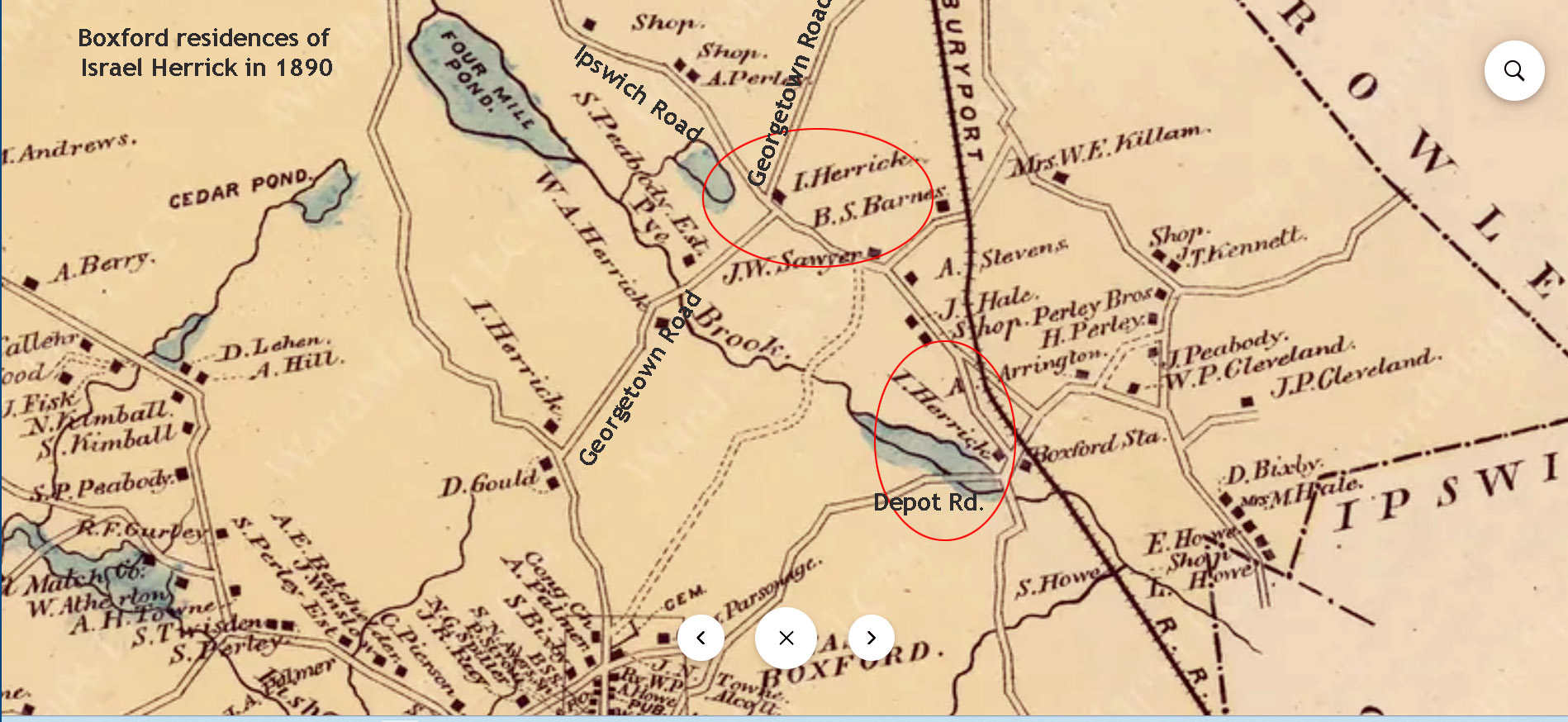
Joseph Bixby Sr.: Historian Sidney Perley wrote that Joseph Bixby’s house was in the area between Depot Rd. and Georgetown Rd. in Boxford. The house is no longer standing. The decision to establish this part of Rowley as a separate town was made by the General Court in 1685. A year later, it was renamed Boxford. Bixby’s land was in the southeast area of Boxford and overlapped Topsfield, in the general vicinity of the intersection of today’s Rt. 97 and I-95.
On 10 June, 1727, Joseph Bixby 3rd sold to John Andrews, Jr., of Boxford, twelve acres of land in Boxford “with a dwelling house thereon, it being the house and part of the land that was my father’s, Joseph Byxbe, deceased.” The same day he sold to John Bixby, for £112, twenty-six acres, part of the land which had belonged to his father. The house is no longer standing
Land from the large Boxford farm of Joseph Bixby Sr. was eventually sold to the Herrick family, as shown in this 1890 map. See this location in Google Maps.
Benjamin Bixby
The 1837 Elbridge Bixby House is at 205 Haverhill Rd. in Topsfield, near the former location of Benjamin Bixby’s house.
In 1691, Joseph’s son Benjamin Bixby sold “part of a meadow” in Topsfield, which he “bought of my father Bixby.” (Source: Salem Deeds). In 1696, Benjamin Bixby bought 32 acres from his father, adjoining Hood Pond at the intersection of Linebook Road and today’s Rt. 97 /Haverhill St. (Salem Deeds 35:61). Benjamin Bixby’s house was destroyed by fire on Sunday, June 26, 1859. The Elbridge Bixby House sits near that location.
Windham, Connecticut
In 1712, a division of four hundred acres in the northeast part of Windham, CT, was laid out for purchase and settlement. The valleys were fertile and attractive to third-generation descendants of Essex County settlers who hadn’t inherited large acreage of land. Benjamin Bixby’s son Benjamin 2 moved to Killingly/Thompson, Connecticut. Another son, Samuel Bixby was born in Topfield in 1689 and married Martha Underwood Killingly of Windham County, Connecticut, in 1718. He died, probably in 1741. He was one of the early settlers of Sutton, Massachusetts. Their children were: Benjamin, born 17 April 1726; Jonathan, born 29 Sept. 1728; Sampson, born 3 March, 1731; and Solomon, twin with Sampson.
The intersection of Rowley Road and Route 97 was known as Bixby’s Corner. The 1910 map shows two of the Bixby family houses near that location.
Deacon Samuel Bixby House, 101 Middleton Rd, Boxford. Deacon Samuel Bixby built this house in 1828 and lived here until he died in 1881 at the age of 82. His son, Stephen A. Bixby succeeded him in ownership.
The Topsfield neighborhood encompassing River Road, Rowley Bridge Road, Cross Street, and Hill Street is listed in the National Register of Historic Places. View a map of the River Road-Cross Street Historic District.
Cross Street extends from Hill Street to Rowley Bridge Road. On March 2, 1730, “the town accepted the Selectmen’s Laying out a way for George Bixby.” This property was long known as the “Donation Farm” because Deacon George Bixby, the owner, bequeathed the estate to the selectmen of Topsfield, in trust, the income to be applied to the support of the ministers of the Congregational denomination in Topsfield, and the farm to be known as “The donation farm for the support of the Gospel.” Deacon Bixby died Jan. 5, 1825.
The Daniel Bixby House at Meredith Farm, Cross St. in Topsfield dates back to at least 1798, when a two-story house at this location was taxed to Daniel Bixby. He was assessed for twenty-seven windows. It was one of the largest and most highly valued residences in Topsfield. Meredith Farm is a 188-acre privately owned farm in Topsfield.
Meredith Farm is a 188-acre, privately owned farm on Cross St. in Topsfield. In 1689, Joseph Bixby (1621-1703) bought 64 acres in the vicinity of what is now Meredith Farm. In January 1689, Joseph Bixby sold 32 acres of it to his son Benjamin in 1689. In 1691, Benjamin Bixby sold a parcel of land to John Curtis (Salem Deeds 9:29).
In 1722, nearly two hundred and fifty acres of land south of the river, on the west side of the highway leading to Hill Street were divided into three ranges. On the north, the line between the first and second ranges was about where Cross Street is today. The members of the Curtis and Towne families acquired most of the lots in the first range. Before 1730, George Bixby bought a large portion of land in the second range, on Cross St., on which he built his house.
In 1738, George Bixby purchased Jacob Redington’s farm of 57.5 acres near the intersection of Hill and Cross Street. In 1740, he acquired the 20-acre farm and farmhouse from Israel Towne, who moved to New Hampshire. George Bixby then gave his son Daniel half of his dwelling house and barn. In his will in 1783, George Bixby left the other half of his land to Daniel. A cider mill was in operation on the Bixby farm by 1751. Dendrochronology was conducted on the beams in the house on the farm that Daniel Bixby built, showing they were cut in the Fall of 1791 and Spring of 1792. The beams in the barn close by, which is referred to as the 1793 Barn, were cut in late 1792 and early 1793.
In 1845, Daniel Bixby Jr. willed his farm to the Town of Topsfield as the “Donation Farm”, the income from which would help to support the Congregational ministers of Topsfield.
In 1899, J. Morris Meredith, a Boston realtor, purchased the farm from Charles V. Jackman. He built the Main House on the farm in 1900. View a video of the present-day Meredith Farm. View the history at the Meredith Farm website.
River Road, Topsfield
The Daniel Lake-Henry Bradstreet House, 70 River Rd, c. 1760. It is thought that the house was built for Daniel Lake (1726-1810), who was taxed for the one-story house in 1768. He married Sarah Bixby, daughter of George Bixby, in 1749. Her grandfather was Benjamin Bixby, the son of Joseph Bixby, the settler. This house is not visible from the road.
85 River Rd. Topsfield, the Zaccheus Gould House. Sarah (Gould) Bixby, wife of Joseph Bixby, Jr., was a granddaughter of Zacheus Gould, who settled at Topsfield, where he acquired a large landed estate. Zacheus Gould was 72 years old in 1661.
Andover
88 Lowell St., Andover: This house was built before 1673 by Captain Thomas Chandler. His daughter, Hannah married Captain Daniel Bigsby, a carpenter and husbandman. Chandler conveyed to his son-in-law, Daniel Bixby sixty acres of land near the Shawsheen River, April 12, 1688. Chandler died in 1703 and mentioned his daughter Bixby in his will.
In Memory of | Benjamin Bixby son | of Mr. Benjamin & I Peggy Bixby, | who died June 3 1795.
Charles H. | Son of | Daniel & Caroline | Bixby, | Born Feb. 2, 1840, I Died Aug. 23, 1846.
Here Lyes the Body | of Daniel Bixby | who Died, September 22, 1775 Aged 56 Years | & 7 months. “Why do we mourn Departing Friends or shake at Deaths alarms tis but the Voice that Jesus Sends To call them to his arms.” [Revolutionary Soldier.]
Deacon | Daniel Bixby | died | Jan. 5, 1825. “Reader prepare, remember death is near; My time is past, Eternity is here.” [Revolutionary Soldier.]
To the memory of | Cap. Daniel Bixby, died | June 24, 1836. “When the dread summons calls, we must obey; And break all earthly ties, to sleep with clay; How sad would be our lot, how drear the grave, But for that blessed hope our Saviour gave.”
Daniel A. | Son of Daniel & Caroline Bixby, | Born May 30, 1843, Died Aug. 29, 1846.
Here Lyes the Body of M” Elisabeth Bixby, Daughter of Mr. Daniel & Mrs Ruth Bixby, who Died September 18, 1776 1 Aged 33 years. “The Dead are Only Blest That in the Lord do Rest.”
John Q. Bixby, died Sept. 21, 1846, Et. 17 yrs.
To the memory of | Lucinda, Daughter of, Daniel & Sally Bixby, died June 13, 1820. Et 6 years.
In Memory of | Mrs. Ruth Bixby | Relict of Mr. Daniel Bixby, who died Sept. 14, 1808 ^Et. 90.
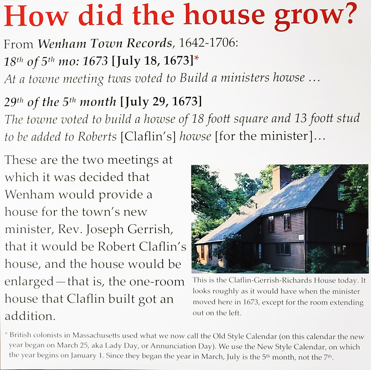
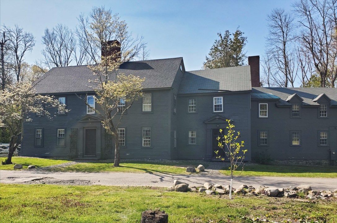
The Claflin-Richards House at 132 Main St, Wenham, is listed on the National Register of Historic Places. The house presents a First Period dwelling room, a late 17th-century minister’s parlor, a circa 1750 bed chamber, and a Victorian-era chamber. The house is named for the first owner of the lot and the last resident before it became part of the Wenham Museum.
In 1672, the town purchased a house and land at this location as a parsonage for Rev. Joseph Gerrish. Sign courtesy Wenham Museum
The first property owner of record, in 1661, was Robert Macklafflin (aka MacLafflin), who, according to family tradition, was a Scottish soldier and was among those taken prisoner and sent over to New England by Cromwell after the border battles of Dunbar in 1650 or Worcester in 1651. He is believed to have been transported to this country on the ship “Sarah and John” and worked here first in the iron works in Saugus, Massachusetts for 10 years, then removed to Wenham where he married. In the records of the town of Wenham, Mass., is the following entry: “4th of November, 1661, Robert Mackclothlan is accepted as a townsman”. Robert Claflin’s will was inventoried 19, Sept. 1690 by Richard Hutton and John Batchelder Sr., who found its value to be £101.9s.6d. A sign at the Wenham Museum as you enter the first room of the house states that it was the 18 ft. square Clafflin home.
Around 1690, the lot was acquired by Capt. Thomas Fiske, the leader of the town’s militia. Capt. Thomas Fiske Jr, 1693-1757, was the leading military man in town and was repeatedly elected to the legislature. In 1700, he was appointed to keep the first school here in the house.
Architectural Features
Exterior
In 1697, the selectmen of Wenham granted Thomas Fiske “pine Timber for building his house and for planke and board,” suggesting that at least part of the Captain’s house was constructed at that time. Architectural historian Abbot Lowell Cummings observed that all major framing members in the oldest part of the Claflin-Richards house, with the exception of posts and a chimney girt. are indeed pine, and that the walls are planked rather than studded.”
The earliest incidences of plank wall construction in Essex County was fairly rare, and are usually found along with overhangs. The demolished 1684 William Story House and the late 17th-century Giddings in Essex, and the White-Ellery House in Gloucester are other local examples of plank framing.
The exterior of the house bears a resemblance to the Whipple House in Ipswich, in which the framing of the oldest section is also pine.
When you enter the Wenham Museum, the rear of the Claflin-Richards house is on your right. The front of the house faces south, as was more often than not the orientation of First Period Houses. Dendrochronology testing has dated the left side of the Whipple House to 1677, and the right side to 1790. Dendrochronology has not been done to determine the actual age and builder of Claflin-Richards House.
The framed overhangs on the Claflin-Richards house are examples of the “Post-Medieval Revival” period of the late 17th century.
Interior
A unique interior feature of the Clafllin-Richards House is the serpentine ogee curved braces, a design found nowhere else in our experience
The frame features decorated posts and quarter-round chamfered summer beams with decorative “lambstongue stops.” Very similar to the Whipple House in Ipswich, this house was designed to reflect the wealth of the owner, Captain Thomas Fiske.
The fireplace in the far room of the Claflin House has rounded corners, similar to the Whipple House.
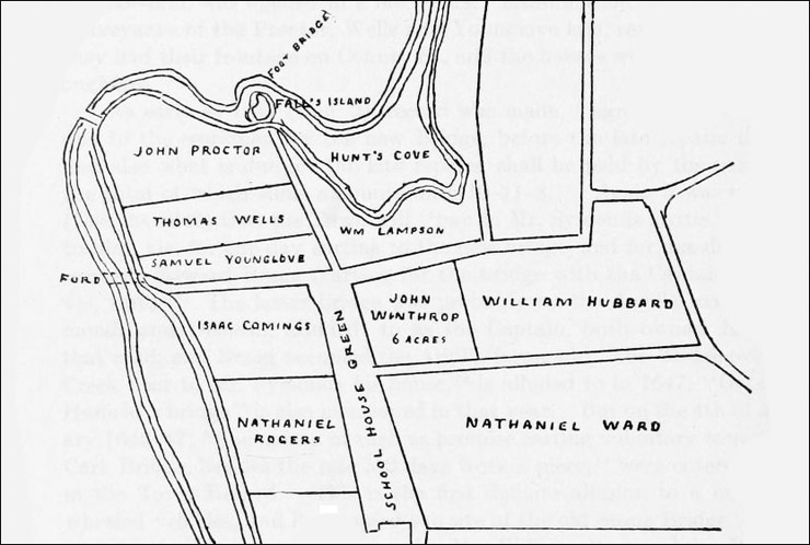
When Roger Preston arrived in Ipswich he first purchased a lot along the river across from what is now the intersection of Turkey Shore and Labor in Vain Roads. The earliest town records show the lot belonging to William Lamson, who died Feb. 1, 1658. In Ipswich in the Massachusetts Bay Colony, Thomas Franklin Waters notes: “William Lampson and William Story, who owned adjoining lots there, sold their property prior to 1644.”
Franklin Thomas Waters’ map of the land grants shows that William Lampson was granted a valuable block of land alongside the Great Cove on the south side of the Ipswich River, beginning at the intersection of County Street and Poplar Street, and continuing in a narrow band along Turkey Shore to Tansy Lane.
“William Lampson was born in England and came to this country in 1634. Of his arrival, we know nothing, but he went to Ipswich soon after he landed, and the records show that on Feb. 5, 1637, there was “granted unto William Lampson six acres of planting ground, between Paul Williamson’s meadow and Goodman Andrews, ten acres near the upper end of Labour-in-Vayne Creek.” In 1640, he received another grant of land, and in that year it was voted that “the highway to Chebaco beneath Heartbreak Hill (Argilla Road) forever be repaired by the benefit of the grass yearly growing upon the same,” and John Leigh was to enjoy all the profits for “maintaining the highway from Rocky Hill to William Lampson’s lot.” (editor’s note: Old England Road).
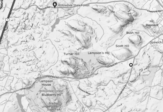
This 19th-century photo of “The Lampson Homestead” is found in “Descendants of William Lamson of Ipswich” published in 1917 by William J. Lamson. The earliest record of a house in this location is 1680, The eastern end dates to 1840, and whether the oldest sections in the western section still remains is unknown. It is still standing within Bradley Palmer State Park in Topsfield. Read about this house
“On the bank of the Ipswich River, on a point jutting out into the stream at the end of the road leading to Labour-in-Vayne meadows, William Lampson was granted a house lot “in the beginning” and it was expected that this attractive locality, called the Turkey Shore, would become a compact neighborhood; but the houses disappeared, however, and some lots were never utilized. William Lampson and William Story, who owned adjoining lots there, sold their property before 1644, and the neighborhood evidently did not prove popular. He also had a grant of about one and a half acres a little further up the river on the Turkey Shore, bordering on Hunt’s Cove, and this was sold to Deacon Whipple in 1649. There was also granted to “‘Wm. Lamson 6 acres of salt marsh near Hog Island by John Dane, his Island.’ There is a hill in Ipswich named Lamson’s Hill since 1678, and perhaps earlier. His farm is still owned by his descendants.”
The farm referred to is the Lampson Homestead in Bradley Palmer State Park. Lampson’s Hill Pasture” is identified in a 1750 deed as “bounded westerly by Turner’s Hill, southerly by the road to Topsfield, north by Bush Hill.” It was part of the Bush Hill Eighth when the common lands were divided into 8 parts in the early 1700s. Today Lampson’s Hill is the eastern end of the Turner Hill Golf Course.
“Thus we see that William Lamson was early a man of property, and from the extracts from the town records we find him to have been a man of considerable standing in the community and interested in town affairs. His name appears on a list of Freemen of Ipswich, on May 17, 1637. This shows that he was a member of the church in good standing and thereby entitled, after taking the oath of allegiance, to vote for the officers of the Colony and take part in town affairs. In 1641 he was entered as a Commoner on the Town Book of Ipswich, which showed that by owning a house and land within the bounds of the town, he was entitled to the right of pasturage for his cattle in the wide domain beyond the Common fence. These Commoners, from the very beginning, met in Commoners’ meetings, had their own records, legislated regarding all the duties and privileges of Commoners, and voted on all questions relating to the common lands.
In 1657 it was “ordered that Wm. Lamson (and others) pay 12d y head to the cow keeper for their cows going on the Common according to an order made in March last.” One of the earlier offices that he held was that of Pounder, and the duties were to care for stray animals, shut them up in the public pounds, and collect the fines due.
The estate of William Lampson of Ipswich is recorded in the Essex Probate Docket # 16264 and 16265. Administration on the estate of William Lampson of Ipswich was granted Mar. 29, 1659, to widow Sarah. Inventory was taken on Feb. 11, 1658, by William Goodhue and Robert Lord. It included the house & ground about it, two acres of marsh,
He left eight children, four sons, and four daughters. The eldest son was sixteen years last November, the eldest daughter fourteen years, the second son nine and three-quarter years, the second daughter seven, the third daughter five and one half, the fourth daughter four, the third son two years last November, and the youngest son twenty-four weeks old. Administration of the estate was granted to the widow and ordered that she pay or cause to be paid to the children as they came to age or marriage with her consent and that the house and land stand engaged to make good the legacies. (Essex County Probates Files, Docket 16,264)
The widow Sarah Lampson apparently married again, and combined her estate with the estate of her second husband, Thomas Harteshorne of Reading, to provide payments to the children, according to Ipswich court record of Mar. 19, 1659. “It was agreed that before marriage he should sign and seal a writing to give our sayd sister power & liberty to dispose of the one half of the estate she brought to him by way of will (of which there is sufficient witness besides our selves) but by providence that writing being neglected to be finished before marriage (though then promised it should be done after) but it is now refused and thereby the children of our Brother William Lampson like to suffer.”
Thomas Hartshorne of Redding tendered as security, instead of the land at Ipswich, his house in which he dwells, and fifteen acres of land in Redding, bounded on the north by land of James Pike, on the south by land of Walter Fairfield, on the east and west by the common; also three acres of meadow at Reeva in the same town, bounded on the north by the meadow of Henry Felch and by the commons on the other three sides; also four acres of meadow in the great meadow in the bounds of Lynn, bounded on the north by the meadow of Edward Hutcheson, on the south by the meadow of Isaack Harte, on the west by the common, and on the east by Isaack Hart’s farm. Accepted 11:10:1661
The Lamson family multiplied in the Ipswich area, and within a few years the family name was listed on Linebrook Road near Topsfield, and in the Hamlet (now Hamilton).
Bradley Palmer
Bradley Webster Palmer (1866–1946) was a prominent U.S. attorney and businessman. He was involved with the creation and development of multiple corporations, including the United Fruit Company, Gillette Safety Razor Corp., and International Telephone & Telegraph Corporation. He was also part of the American delegation at the Paris Peace Conference following the First World War.
Around 1891 Palmer began to acquire over 10,000 acres near the Ipswich-Topsfield line. In 1898 Palmer purchased the hereditary farm holdings of the Lamson family, some 747 acres, and built a stone mansion near the Lamson house, leaving it standing. He named the estate Willowdale. During the years from 1937 to 1944, Palmer donated all of the property to the Commonwealth of Massachusetts, leasing back the 107 acres surrounding his mansion. The state established Bradley Palmer State Park and Willowdale State Forest on the properties.
The Newburyport Interactive History Map is a project created by Mary Baker Eaton, producer of The Newburyport Blog. It chronicles stories about the houses, people, places, events, streets and ancient roads that make up Newburyport’s rich history. View a list of all the entries that will be showcased. Many of the entries on the map are also explored in more detail at the History~Newburyport site.
John Wheeler moved to Newbury MA by 1650 and obtained considerable acreage at this location. He died in 1662. His son David married Sarah Wise and moved to Rowley in 1669, but maintained possession of the property he had acquired by purchase and inheritance. David’s son Nathan was born in 1669 and purchased a lot along the river from his father to establish a mill. He died in Newbury, age 88 in 1755, presumably at this location. In his will, he deeded 1/3 of his house to his wife Rebecca, and the remainder of the estate to his son Nathan2, who was born in 1701 and is believed to have been the original builder of this house, probably after he married 24-year-old Mary Plumer in January 1724-5.
At a meeting of the freeholders and inhabitants of Newbury, held December 9, 1701, a request by Nathan Wheeler and others was granted for an abatement of their dues to the First Church in Newbury because of the distance they lived from town. On October 13, 1706, Samuel Brocklebank, Jonathan Wheeler, Benjamin Plumer, Nathan Wheeler, John Brown, Andrew Stickney, and their wives, also Mary Chute, and Elizabeth Look, were dismissed from the Rowley church, to join the church in Byfield, sometimes referred to at that time as “Rowlbery.” On October 28, 1710, the General Court ordered that the area around Newbury Falls be set off by Newbury & Rowley, as an acknowledged and established precinct commonly called Byfield.
Nathan, Jr. was given land for a mill and 1/2 of all of Nathan, Sr’s. land in a 1734 filing, then by Nathan Sr.’s will proved in 1741, he received all of his father’s land. In 1799 there was no male heir and thus Nathan, Jr.’s daughters Rebecca Noyes and Sarah Sawyer sold Nathan’s estate to Joseph Pearson. Nathan Jr. had grown the estate from 30 acres to 70 during his stewardship. Thomas Rand Larkin bought the house attached property in 1822 and lived there until he died in 1851. The Story of Byfield Parish notes that “Mr. Horsch’s place was anciently a Wheeler place,” and the 1884 Newbury map shows the Horsch house at this location with its neighbor shown as “C. Noyes.”
Structural observations
The Newbury assessors list a date of 1690 for this house. While some of the frame may be from a pre-existing 17th-century building, structural evidence for the house points to a period of about 1725-30, with a later saltbox addition that was subsequently replaced with a modern ell.
There is no soffit or frieze board, and the upstairs windows are tight to the edge of the roof, which is found in First Period houses (before 1720), but continues to be found in some houses through the 18th Century.
Houses in surrounding towns with a similar half-house configuration date to the transitional era between First Period and Georgian, about 1725-1730
The summer beams were originally cased, are sawn, and have no chamfers, indicating early Georgian construction (after 1725).
The gunstock posts and girts protrude inside but were originally cased.
The spacing of the principal rafters in the attic is unusually long, with one on each side but only one in the middle.
The stone foundation does not perfectly fit the house frame, possibly indicating that parts of an older frame were used.
The three fireplaces are in the rear center of the house, sitting on a massive stone foundation., were probably added when the house was extended with a shed that no longer exists. The brick chimney is mortared with clay and sand, rather than lime. The bricks appear to be hand-made and are slightly larger than modern bricks. They may be reused, or they may be evidence of an earlier construction date.
The small kitchen hearth is at the rear of the original building, somewhat similar to a Rumford fireplace, and probably hides a larger original hearth The bake oven and another opening are outside the fireplace on the right.
The Mill
The Larkin Morrill Snuff Mill first operated in the 18th century as a sawmill and was converted to snuff manufacturing by 1804, if not before, when it was bought by Dr. Samuel Tenny who milled snuff until 1811. Between the years 1822 and 1837, Thomas R. Larkin, a “tobacconist”, purchased the mill. His partner in the business was Orlando W. Morrill, hence the name “Larkin Morrill Snuff.” After Larkin”s death, his heirs sold the major interest in the mill, property, and mill rights to Gorham D. Tenny and Daniel Bailey in the decade of the 1870s. In 1899 the mill was sold to the newly incorporated Byfield Snuff Company by Tenny & Bailey who maintained an interest in the company as stockholders.
The Massachusetts Historical Commission’s MACRIS site refers to this as the Pierce House. On June 25, 1828, Nathaniel Noyes (son of Joseph Noyes Jr.) sold the house and land to Enoch Pierce, for $400, and the property remained in the Pierce family for 40 years. Prior to the Pierce ownership, the house and land had been owned by members of the Noyes family for 116 years.
The MACRIS page provides an estimated construction date of c. 1725, based on the year that streets running from High St. to the Merrimack River (including Bromfield St.) were laid out. Deeds for this lot include a sale by Joseph Knight to Joseph Noyes in 1712, the same year that dendrochronology tests indicate the wood for two oak corner posts was cut. The tree for the two oak chimney posts was cut in 1707.
The wood for some of the structural elements of the original one-over-one house is significantly older. The oak lentil for the parlor hearth appears to have been cut in 1678, and a cutting date of 1673 was determined for three structural features: a spruce attic tie, a spruce corner post, and the massive white oak summer beam in the parlor. The framing was boxed in the mid-18th-century Georgian fashion, but the frame in the downstairs parlor room was subsequently exposed.
The earliest history of this house is unclear, but the most likely scenario is that a 1678 oak post and beam one-over-one frame from another location was disassembled and reassembled at this location in 1712 by Joseph Noyes, a “house carpenter”. The frame was clearly exposed to the weather for several years, and the mortise and tenon joints show signs of displacement. The full basement and the large fireplace in the parlor were created in 1712. The earlier structure may have not included a chimney bay.
The house was significantly altered and enlarged around 1774. The chimney bay on the east side was rebuilt, a saltbox lean-to was added at the rear, and the stairway was altered to provide access to the attic over the lean-to. At the same time, the stone foundation for the large downstairs fireplace was replaced with brick arches. Modern fireplaces were constructed for the lean-to and the second-floor bedroom, and the chimney was reconstructed, as well as the two bake ovens.
Bromfield Street
“Cottle’s lane, from High street by Ezra Cottle’s dwelling house, to the dwelling house of Joseph Knight, Junior, on the highway near Merrimack river,” was laid out by the selectmen of Newbury March 6, 1718, although it was probably a private way long before that date. In 1764, the easterly side of Cottle’s Lane, was, by an act of the General Court, made the dividing line between the towns of Newbury and Newburyport, and the name of Cottle’s Lane was changed to South Street by the inhabitants of the last-named town. In 1851, “An Act to Annex a Part of the Town of Newbury to the Town of Newburyport ” established a new dividing line between the two towns, and, on November 1, 1852, by a vote of the city council of Newburyport, the name of South street was changed to Bromfield Street in honor of John Bromfield who, by his will, proved January 14, 1850, gave ten thousand dollars to the inhabitants of Newburyport, the income to be used for the purchase of shade trees and the improvement of sidewalks.” (History of Newburyport, Mass. 1764-1909 Vol. I by John. J. Currier)
Ownership of this property
Joseph Knight
John Knight (1594-1670), a tailor by occupation was a selectman and a prominent individual in the early settlement. He received permission to keep an ordinary in 1637 and held several offices, including selectman. When the town was moved in 1645 from its original location at “Old Town” on the Parker River to the west bank of the Merrimack River, Joseph Knight Sr. was assigned “a house lot at the new town joyning South Street.” (*South Street in 1645 was at the southern end of the new town, and is known today as Parker Street.)
John Knight’s grandson Joseph Knight (1652-1725), came into possession of several properties with multiple acreage in a series of deeds during a period from 1702-1709. This included a narrow lot “by ye highway of two rods wide next Merrimack River.” (Salem Deeds 22-146). In one of the deeds, he was granted a lot by his father “in consideration of his good service and dutiful obedience of me and also in consideration of a contract of marriage to be consummated with Deborah Coffin ye daughter of Tristam Coffin of Newbury.” (Salem Deeds 22-148). No mention of a building is found in these deeds.
The earliest known evidence for the Noyes’s ownership of this lot comes from the historical record of Cottle’s Lane, as recorded in Currier’s History of Newbury page 426: “April 4, 1710, voted to give eight pounds towards ye procuring of a way proposed for thru’ ye Little field provided ye sd way be laid out two rods wide the whole length from Ezra Cottle’s house to ye way by Henry Clarks next Merrimack River according to a vote of ye Town December 18, 1695. This way, called Cottle’s Lane, now Bromfield Street, Newburyport, was laid out, March 6, 1718-19, from High Street, by Ezra Cottle’s dwelling-house, to the dwelling-house of Joseph Knight, Jr., on the highway near Merrimack river.”
Joseph Noyes
Recorded December 29, 1712, Joseph Knight “blacksmith” conveyed to Joseph Noyes, “house carpenter” for £21, a certain piece of land containing one acre “bounded southerly by my own land, westerly by land of Henry Jacques, northerly by land of Joseph Hale, easterly by the highway, with all profits, privileges & appourtenances to ye same.” No mention is made of a house, but the deed states that “Joseph Noyes has been in possession of the premises.” (Salem Deeds 32-224). The low price may indicate that the lot was empty, or that it had on it an unfinished building that is today’s 8 Bromfield St. A year later when Joseph Knight sold land to Marvarick Gillman (Salem Deeds 26-223), the deed states that the lot was bordered by the land of Joseph Noyes northwest.
The Noyes family of Newbury
The Noyes family, like the Knight family, was significant in the early history of Newbury. Joseph Noyes Sr. (1686-1773), was the son of Lt. Col. James Noyes Sr. (1657 – 1725) and Hannah (Knight) Noyes (1664 – aft. 1723). The lieutenant was the son of Nicholas Noyes (1615 – 1701), who along with his brother James and father William were prominent figures in the settlement of Newbury in 1635. James Noyes Sr. is credited with the first discovery of lime in the Massachusetts Bay Colony. Major James Noyes was among 3 men chosen to settle and determine the bounds and measurements of the highways in the Town of Newbury.
Joseph Noyes (1688 – 1755), built (or rebuilt) the house in 1712. He married Elizabeth Knight. During his life in Newbury he inherited and purchased multiple parcels of land. Beginning in 1736, Joseph Noyes made many transfers of property unrelated to this lot, which is probably indicative of the year that he moved to Falmouth, ME, where he died in 1755. A few of the unrelated transfers are listed here. It is unclear if the house on Bromfield St. remained in the Noyes family until it was sold by Nathaniel Noyes in 1828.
He sold one half of a “certain messuage or tenament” and upland to Joshua Noyes for £165.00 (Salem Deeds 72: 171), having previously belonged to David Parsons.
He sold property to Samuel Bartlett for £142.00. ( Salem Deeds 72:159). The deed states that it was part of Deacon Nicholas Noyes’ freehold lot on the Artichoke River. He sold a second property to Samuel Bartlett for £103.00. (SalemDeeds 73:167)
In 1740, Joseph Noyes, now of Falmouth sold to Jacob Noyes, blacksmith, a portion of the saltmarsh and meadow land that had belonged to Joseph’s father, Cutting Noyes Sr. (Salem Deeds 80:200).
In 1746 he sold to “my kinsman” John Noyes one half of 14 acres of pasture land with orchards and buildings, “bounded northeasterly by my own land” (Salem Deeds 89:173)
In 1749, he sold some acreage to his son Cutting Noyes Jr. (Salem Deeds 120:257).
Noyes family’s possible line of ownership of this property
Joseph Noyes (builder of this house)
Cutting Noyes Jr. (1676 – 1757) and Elizabeth Tappan Noyes. He was the brother of Joseph Noyes. His estate on King Street (now Federal Street) was divided by his descendants in 1771, with the individuals each owning a small portion of the house. (Salem Deeds 129:198)
Jacob Noyes Sr. (1704 – 1786) and Jane Titcomb Noyes. Parents of Capt. Joseph Noyes Jr.
Nathaniel Noyes (1763 – 1847) sold the property to Enoch Pierce in 1828
The 1851 map of Newburyport shows “Heirs of E. Pierce” at today’s 8 Bromfield St., which was called South Street at that time.
Pierce ownership
On June 25, 1828, Nathaniel Noyes (son of Joseph Noyes Jr.) sold the house and land to Enoch Pierce, for $400. (Salem Deeds 253-253) bounded southeasterly by South St., “with the buildings thereon.” South St. was renamed Bromfield St. in 1851, soon after the 1851 “Plan of Newburyport” shows the “heirs of E. Pierce” as the proprietors. Pierce served under the command of Ezra Lunt in the Revolutionary War at the age of 20. On Sept. 20, 1872, John Pierce sold to Joseph Howard, $250 for the lot and buildings. (Salem Deeds 864-36). Captain Joseph Howard had a fish market at 11 Huse Wharf.
The early house
The two rooms in the one-over-one oldest part of this house measure about 19′ wide x 20 ft. deep. It is unclear if there was originally a chimney bay on the right.
The layout of the oldest section of the house at 8 Bromfield St. may have been similar to the 1654 Coffin house in Newbury. Image from “The Framed Houses of Massachusetts Bay, 1625-1725” by Abbott Lowell Cummings.
Section of oak summer beam in the downstairs older section at 8 Bromfield St. Dendrochronology indicates that it may have been re-used from a 1673 structure.
The exposed frame is weathered and gray, indicating that it sat for a period of time exposed to the weather, and the structural elements have remnants of old whitewash. The unchamfered massive oak summer beam is laid flat rather than vertically and measures about 15″ wide x 8″ high, an unusual installation. Summer beams in the 1667 Giddings-Burnham House and basement summers in the c1700 Perkins-Hodgkins House in Ipswich are also laid flatwise. In all four corners of the upper room in the oldest part of this house are massive gunstock posts, outlining the configuration of the two original rooms.
Downstairs summer beam & girt
Downstairs front corner post, plate, and girt
The weathering of the frame in the original core of this house indicates that it was constructed years or even decades before the lot was purchased by Joseph Noyes in 1712. The lack of a chamfer on the summer beam in the original structure suggests that it was constructed before 1680 or was a utilitarian building. It is unknown if the early house was constructed at this location or was moved here as has been conjectured. There is some separation in the joinery, and the exterior walls are out of plumb. This could have occurred if and when the structure was moved, but can also be attributed to the age of the structure and its early exposure to the elements, which resulted in the deterioration of some of the trennels that hold the joints together.
Masonry
The first-floor fireplace at 8 Bromfield St.
An outstanding feature of this house is its 9′ fireplace, examples of which are found from the late 17th Century into the first half of the 18th Century. The bricks are somewhat shorter in height and have clay mortar, which was used in the 17th Century and early 18th Century. The existing chimney bay is part of the 18th-century alteration, with the stairs ascending over the rear of two bake ovens.
Above the fireplace lintel is a plastered brick cove that supports the hearth of the second-floor fireplace. Abbott Lowell Cummings wrote that of the plastered coves he had observed, none dated to earlier than the last quarter of the 17th Century:
The 1678 Tristram Coffin House, Newbury (Dendrochronology has not been done on this house)
The circa 1700 Beniah Titcomb House, moved from Newburyport to Essex. (Dendrochronology has not been done on this house)
Bake ovens and a shelf in the rear wall of the first-floor front fireplace. Bake ovens shifted forward for safety in the 18th Century. Firebox openings before the 1720s usually measured seven to nine feet wide. (Reference: Antique Houses by Edward P. Friedland.)
Looking up into the flu of the downstairs front room fireplace, the metal bar on the right indicates the flu was constructed before 1740 when the swinging crane came into favor. (Reference: Antique Houses by Edward P. Friedland.)
A brick arch was constructed in 1774, with an unusual stone sidewall supporting the pre-existing first-floor hearth. Brick arches are commonly found between 1740 and 1830, according to historic masonry expert Richard Irons.
The second floor of the oldest section
18th-century Georgian interior finish is found throughout the house, with the exception of the first floor of the oldest section, where it was subsequently removed.
Fireplace with Georgian moldings on the second floor
Mid-18th-century knob and latch on the second floor. Known as open box locks, the knobs are cast brass on either side of the door, but the mechanism is iron. (Reference: Antique Houses by Edward P. Friedland.)
The other side of the same door
Right side chimney bay addition and lean-to
When the house was altered in 1774 the winder stairway was modified so that it forks to bears left to the second floor of the original house, while the rest continues straight to an upstairs hall which provides access to a finished attic room. This hall also connects to a triangular attic area that was created when the saltbox lean-to was added.
The post on the north wall where the chimney bay stairs meet the lean-to framing is not flared, is made of pine, and dendrochronology dates it to 1707. Assuming it was replaced when the lean-to was added, there would have been no reason to flare this post.
This scarf joint on top of an original gunstock post on the second floor may indicate that the framing of the chimney bay was replaced or altered.
Another view of the rear upstairs beam and scarf joint
These marks found along the length of the upstairs rear beam may have been made by the “dogs” that moved wood in antique sawmills.
The attic room over the old part of the house shows the original principal rafters (minus their purlins) and above them are the rafters for the lean-to.
A dip in the roof in this view from the rear of the house indicates where the chimney bay addition was added or altered.
The fireplace in the lean-to is relatively small and does not have a bake oven.
8 Bromfield in a 1980 photo on the MACRIS site.
Dendrochronology report
On August 1st, 2023, a selection of timbers was cored by William Flynt from the Joseph Noyes house, located at 8 Bromfield Street, Newburyport, Massachusetts for the purposes of conducting a dendrochronology study. All samples were mounted, sanded, measured, and analyzed by Mr. Flynt. A total of twenty samples were taken from the frame that appears to be constructed with a mix of reused and site-specific material. Species encountered included white oak, black ash, white pine, and spruce.
The wood for the parlor summer beam may have been cut in 1673 (although the evidence is weak). An oak southwest rafter and an oak purlin in the southeast bay returned dates of 1673 as well. The two oak chimney posts returned a date of 1707, as well as a black ash rafter on the west side. The oak parlor hearth lentil showed strong evidence of having been cut in 1678. The year 1712 was established for the southwest and southeast corner posts. A cutting date of 1773 was found for a spruce attic tie in the north wall, a spruce corner post, and a white pine corner post on the northwest side.
Discussion (by Bill Flynt): “While a relatively small structure, the Joseph Noyes house frame posed significant challenges due to the incorporation of clearly reused material, some quirky joinery where the entry bay frame joins the parlor/chamber bay at the plate level, and the use of softwood species in the entry bay frame but hardwood in the parlor/chamber bay. A review of the results of the dendrochronology testing suggests the reused material comes from a structure(s) constructed in the 1670s that gets used in conjunction with material felled during the period 1707-1712 (three being critical posts) most likely related to the initial build of the house.
“One would expect this structure to have included an entry bay, as it currently has, but it is difficult to explain why it may have been removed in the 1770s when the softwood framing was felled that currently supports this section. It is possible the evidence of weathering on some of the framing located on the backside of the upper chamber indicates that the structure was in disrepair by the early 1770s. It is worthy of note that one of the two samples taken from the removed lean-to rafters currently stored in the basement also indicates a 1773 felling date, suggesting that perhaps the entry modifications were undertaken at the time of the lean-to addition (though having only two samples from the lean-to roof is certainly less than ideal, especially when only one dated, for conclusively dating any construction event). “
Thomas Franklin Waters wrote in “Candlewood” that the lots at 68 and 74 Essex Rd in Ipswich were part of the original grant to Rev. Nathaniel Rogers, who was ordained pastor of Ipswich, Massachusetts, on 20 Feb. 1638, succeeding Nathaniel Ward as co-pastor with John Norton. He died at Ipswich on 3 July 1655, aged 57. As was customary, desirable residents were granted a lot for a house in town, and a larger lot beyond the town commons for a farm. The farm was inherited by Rogers’ two sons, John Rogers who had become president of Harvard College, and Samuel, who received a house and 8 acres (Ips. Deeds 5: 146).
The house at 68 Essex Rd. in Ipswich was built in 1832
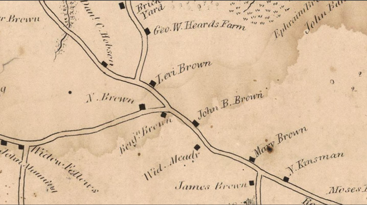
In March 1832, George W. Heard sold an acre and a half to Levi Brown, who had bought a half acre from his father. The Brown family were prominent settlers of the Candlewood area. He built a dwelling that stands at 68 Essex Rd., and is known as the “Levi Brown house.” Brown quitclaimed to his brother Francis, who sold to Henry S. Holmes, 2 acres and buildings, March 9, 1842 (330: 18). Holmes sold to Willard B. Kinsman, April 1, 1851 (456: 112), who enlarged the 1832 house by building a connected new house facing the highway.
The Patch family of Ipswich was related to the Brown family of the Candlewood neighborhood through marriage. Margaret Patch deeded property with a building thereon to Emily Patch in 1897. The 1910 Ipswich map shows a house just to the east of 68 Essex Road occupied by “Miss Patch.” Emily G., Patch, a single woman acquired the property from her mother Margaret Patch in 1897, and appears to have lived in the house for her entire life. The property was willed to Anne Bell Burrage by the will of Emily G. Patch in 1950.
74 Essex Rd. in Ipswich was originally added to the house at 68 Essex Rd in 1851.
Anne Bell Burrage
In 1953, the front part of 68 Essex Rd. was separated from the rear section and was moved to the adjoining empty lot at 74 Essex Rd., purchased by an Anne Bell Burrage, wife of Albert Cameron Burrage Jr. from Neil C. Raymond. The combined Burrage property was referred to as the “Patch Trust.” Mr. Burrage was the son of Albert Burrage, a wealthy industrialist residing in Boston who became president of the Massachusetts Horticultural Society in 1921 and was the founding president of the American Orchid Society. In 1933, seven women met at the Ipswich home of Mrs. Albert C. (Anne) Burrage, Jr. and formed the Herb Society of America for the intent of research and study.
The house still standing at 68 Essex Rd. is owned by the Raymond family under the title “Buttonwood Trust.” The 1832 front addition that was moved to 74 Essex Rd. in 1953 or 1954 is the Willard B. Kinsman house.
Conveyance by Nathaniel Rogers to his son Samuel Rogers, who received a house and 8 acres (Ips. Deeds 5: 146).
Conveyance by Holmes sold to Willard B. Kinsman, April 1, 1851 (456: 112)
Conveyance by Margaret A Patch to Emily G. Patch in 1897: Salem Deeds 1504, page 577. The deed includes a parcel of land with buildings thereon, and refers to land of Stone and Carlisle abutting.


 ” by Abbott Lowell Cummings.