This interactive Google map shows the locations of the homes of Joseph Bixby and his descendants. Click on the icons to read the information provided. The houses that are still standing feature photos of the houses today.
The Boxford and Topsfield cemeteries both have at least a dozen Bixby gravestones, although most of them date to the 19th century.
Joseph Bixby
The name of Bixby is variously spelled as Bigsby, Bixbe, Byxbee, Biggsby etc. Joseph Bixby, was baptized at Little Waldingfield, Suffolk, England on October 28, 1621, son of George and Ann (Cole) Bixby. [1] [2]. Joseph is thought to have emigrated to New England about 1638, but his name doesn’t appear in records until the time of his marriage in 1647, when he subscribed to support General Daniel Dennison. His occupation was carpenter. He married Sarah Riddlesdale Wyatt, the widow of Luke Heard sometime after 15 Dec 1647 in Ipswich. (source: Wikitree)
Sarah’s mother, Mary, was the widow of Edward Riddlesdale, who died in England. Mary married second, John Wyatt, who died in Assington, Suffolk, England. John Wyatt possessed a house lot on today’s Washington Street in 1638, adjoining a house lot granted to Mr. John Norton. These house lots were separated from the majority of the town by the former wetland that extended from the length of today’s Central St. Wyatt purchased from Nathaniel Bishop of Boxton on March 10, 1652, a house and land at today’s 36 North Main St., a pasture lot extending down the north side of Warren St. Wyatt died January 15, 1664-5, and left a widow, Mary, and house and lands valued at £177.00. Mary married third, James Barker, on 23 May 1666 in the part of Rowley, Massachusetts that is now the town of Boxford.
There is no record of Joseph Bixby owning a house or land in the present-day boundaries of Ipswich. On Dec. 22, 1649-50, in company with three others, Joseph Bixby obtained a grant of a house lot and meadow from the town of a meadow, not to exceed 16 acres, by Edward Lomas’ meadow that had already been granted near Mr. Rogers’ farm. The Rev. Nathaniel Rogers succeeded Nathaniel Ward as co-pastor with John Norton at Ipswich, and received a grant of 300 acres, laid out in Feb. 1650. The grant lay between the Ipswich River on the south, Gravelly Brook on the east, and Howlett’s Brook on the west. Men received these grants as reimbursement for their investments in the colony and made a profit by selling their farms as lots. This part of Ipswich, known as New Meadows, became the town of Topsfield in 1650.
In 1658, Joseph Bixby signed a petition protesting that several men of Ipswich had not been declared freemen, although they had taken the oath of allegiance. In 1661, Joseph Biggsby, Adam Redington, and William Foster purchased a large tract of land on the outskirts of Rowley, which became the town of Boxford.
In 1661, Joseph Bixby, along with Adam Redington and William Foster purchased a large tract of land in Rowley Village. Joseph’s 1/6 portion was about 500 acres, of which half he sold immediately to Robert and Nicholas Wallis. He moved to Rowley Village in the same year.
Joseph Bixby was chosen sergeant of the “soldiery of Topsfield and the Villages adjoining thereto,” and was a soldier in King Phillip’s War, 1675-76, the first service into which Boxford soldiers were ordered, in the company of Capt. Samuel Brocklebank. Bixby escaped the tragic fate of most of his company near Sudbury on the morning of April 21, 1676, while he and a few others remained behind to guard the garrison house at Marlborough.
He was a party in a case taken to the General Court in 1673: “To the Honorable General Court now sitting in Boston, this 7th of May, 1673. The Humble petition of divers well affected Inhabitants and House-holders of the Village commonly called Rowley Village. ” Humbly sheweth, That whereas your petitioners formerly purchased a tract of land of Joseph Jewett of Rowley, now deceased, on which we now dwell, whose land was sold to us as village land, free from any engagement to the town of Rowley, else we had not purchased it; as also it lyeing nigh to the now town of Topsfield, whose inhabitants about ten or twelve years since, called Mr. Gilbert to be their minister; he was unwilling to accept, unless we of the village would engage to pay our shares in and to publish charges at Topsfield. Upon this, Abraham Reddington, Joseph Biggsby, John Cumins, and the rest of us, being free as we apprehended, agreed to pay our proportions as our honest neighbours of Topsfield.”
After 1674, Joseph Bixby was sergeant of the Rowley company. In 1680, Joseph Bigsbee and William Foster were appointed to inspect the families in the village, which then had twenty-five families within its boundaries. In 1684, he was on the committee to bring Rev. Joseph Capen of Cambridge to be ordained minister of Topsfield. Joseph and his wife Sarah then joined this church. The Parson Capen House is one of the most historic houses in Massachusetts, owned by the Topsfield Historical Society. In 1684, a list of members in full communion at Topsfield included Joseph Bixby Sr. and his wife Sarah, Jonathan Bixby and his wife Sarah, Benjamin Bixby, and Mary Bixby
Joseph Bixby served as the moderator of the Boxford town meeting in March 1687, even though on the tax list, Joseph Bixby was described as “an old, decrepit man.” In 1689, the soldiers of Boxford nominated new officers, as Sergeant Bixby was then aged and disabled. Joseph Bixby was made a freeman March 22, 1689-90, and died April 19, 1700.
The children of Joseph and Sarah Bixby made their homes in Boxford and the adjoining towns of Topsfield and Andover, but some members of the 3rd generation resettled as far as 200 miles away.
The Children of Joseph and Sarah Bixby
Joseph Bixby Jr. was born in Ipswich, Massachusetts, about 1648/9; married March 29, 1682, Sarah, daughter of John and Sarah (Baker Gould) of Topsfield. Resided at both Topsfield and Boxford. His will was proved on October 5, 1725.
Daniel Bixby was born in Ipswich, c. 1651; died on May 7, 1717; married Hannah Chandler of Andover, December 2, 1674.
Benjamin Bixby, born in Ipswich c. 1653; died in 1727; married Mary (?Kimball); lived in Topsfield.
Sarah Bixby born in Ipswich in 1655; died on January 18, 1657
Nathaniel Bixby born in Ipswich in 1657; died on July 11, 1658.
Mary Bixby born in Ipswich February 18, 1659. married (? John) Stone
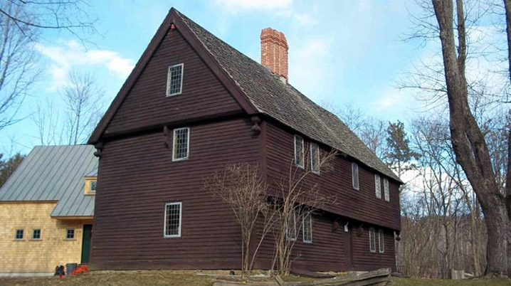
George Bixby was born in Rowley in c. 1660-65; he married Rebecca Porter. Records of the Topsfield Historical Society state that Deacon George Bixby married Sarah Goodhue of Ipswich. He succeeded his father on the homestead and had two sons, one of whom died young. George Bixby probably died in 1729. He was succeeded on the farm by his son Gideon, who was born in 1699 and married Rebecca Foster in 1751. His widow married Solomon Gould of Topsfield in 1756, who lived but a few years. Her son, Gideon Bixby, sold the place in April 1774, for £436 to John Herrick of Boxford, and his mother released her right of dower in it. The farm then consisted of one hundred and eight acres. The location of Herrick’s property in 1800s maps confirms the location of the Joseph Bigsby farm.
Jonathan Bixby born in Rowley c 1666/7; married Sarah Smith of Topsfield, on February 2, 1692. Lived in Boxford; His will was proved May 20, 1717.
Abigail Bixby born in Rowley.
Bixby Houses and Land
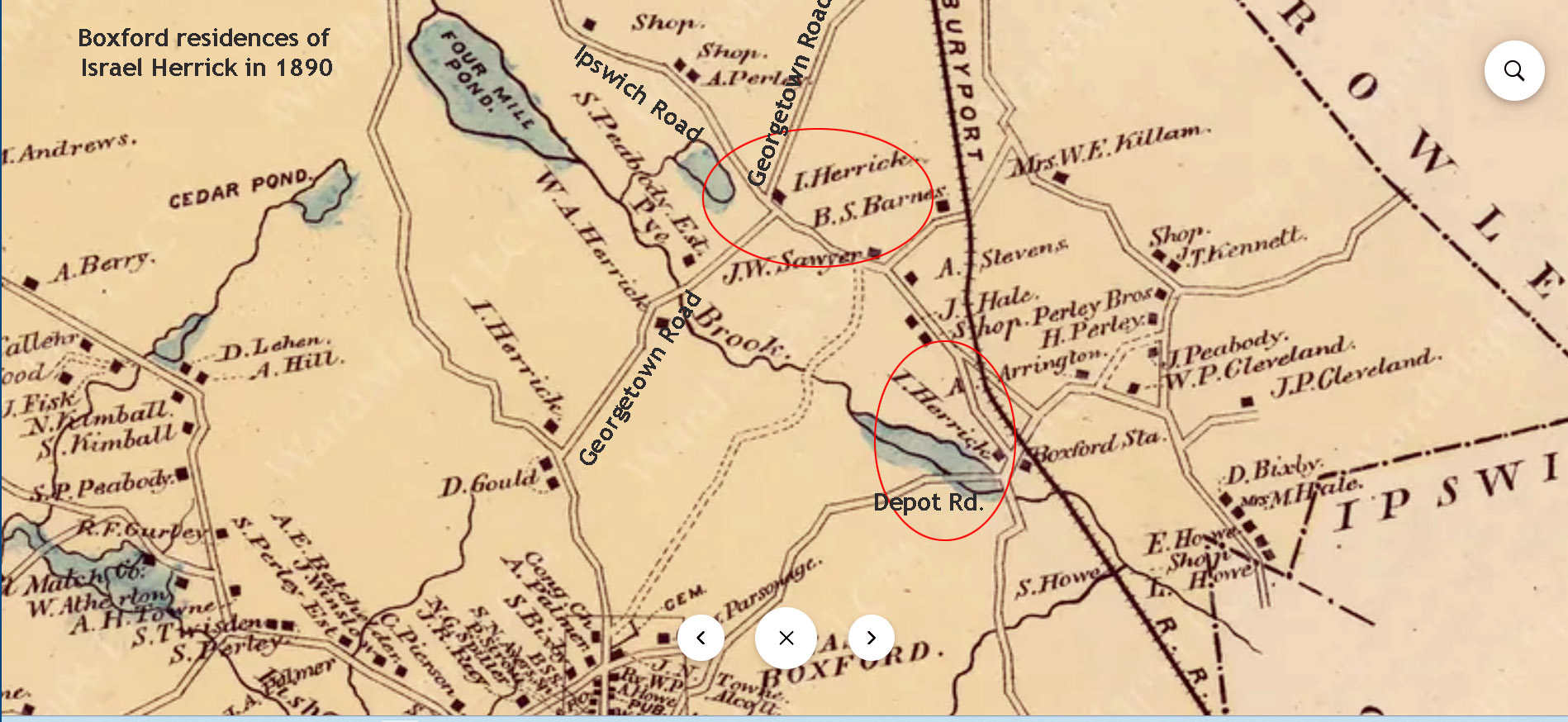
Joseph Bixby Sr.: Historian Sidney Perley wrote that Joseph Bixby’s house was in the area between Depot Rd. and Georgetown Rd. in Boxford. The house is no longer standing. The decision to establish this part of Rowley as a separate town was made by the General Court in 1685. A year later, it was renamed Boxford. Bixby’s land was in the southeast area of Boxford and overlapped Topsfield, in the general vicinity of the intersection of today’s Rt. 97 and I-95.
On 10 June, 1727, Joseph Bixby 3rd sold to John Andrews, Jr., of Boxford, twelve acres of land in Boxford “with a dwelling house thereon, it being the house and part of the land that was my father’s, Joseph Byxbe, deceased.” The same day he sold to John Bixby, for £112, twenty-six acres, part of the land which had belonged to his father. The house is no longer standing
Land from the large Boxford farm of Joseph Bixby Sr. was eventually sold to the Herrick family, as shown in this 1890 map. See this location in Google Maps.
Benjamin Bixby
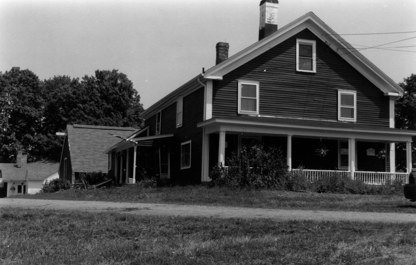
The 1837 Elbridge Bixby House is at 205 Haverhill Rd. in Topsfield, near the former location of Benjamin Bixby’s house.
In 1691, Joseph’s son Benjamin Bixby sold “part of a meadow” in Topsfield, which he “bought of my father Bixby.” (Source: Salem Deeds). In 1696, Benjamin Bixby bought 32 acres from his father, adjoining Hood Pond at the intersection of Linebook Road and today’s Rt. 97 /Haverhill St. (Salem Deeds 35:61). Benjamin Bixby’s house was destroyed by fire on Sunday, June 26, 1859. The Elbridge Bixby House sits near that location.
Windham, Connecticut
In 1712, a division of four hundred acres in the northeast part of Windham, CT, was laid out for purchase and settlement. The valleys were fertile and attractive to third-generation descendants of Essex County settlers who hadn’t inherited large acreage of land. Benjamin Bixby’s son Benjamin 2 moved to Killingly/Thompson, Connecticut. Another son, Samuel Bixby was born in Topfield in 1689 and married Martha Underwood Killingly of Windham County, Connecticut, in 1718. He died, probably in 1741. He was one of the early settlers of Sutton, Massachusetts. Their children were: Benjamin, born 17 April 1726; Jonathan, born 29 Sept. 1728; Sampson, born 3 March, 1731; and Solomon, twin with Sampson.
The intersection of Rowley Road and Route 97 was known as Bixby’s Corner. The 1910 map shows two of the Bixby family houses near that location.
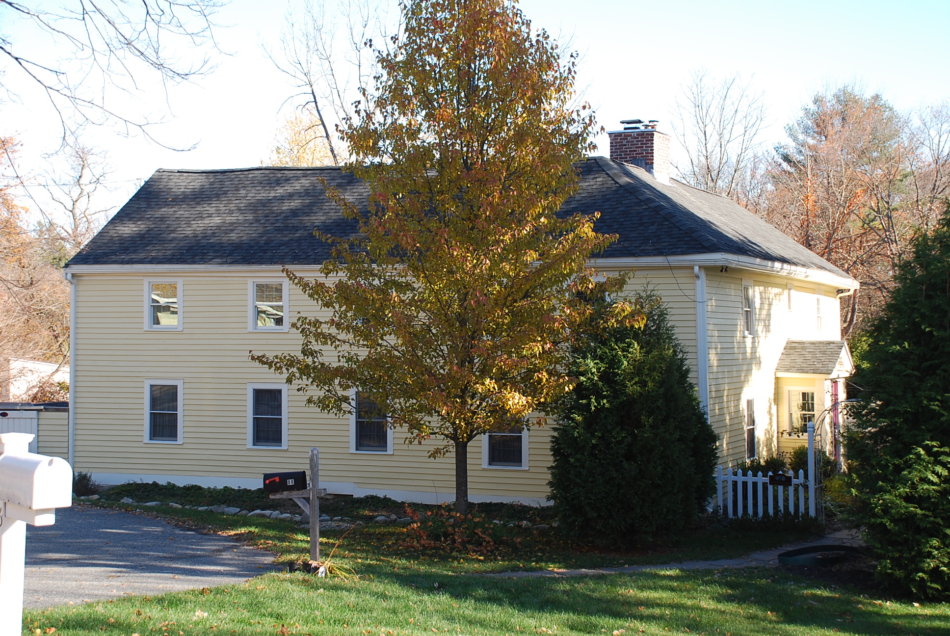
Deacon Samuel Bixby House, 101 Middleton Rd, Boxford. Deacon Samuel Bixby built this house in 1828 and lived here until he died in 1881 at the age of 82. His son, Stephen A. Bixby succeeded him in ownership.
The Topsfield neighborhood encompassing River Road, Rowley Bridge Road, Cross Street, and Hill Street is listed in the National Register of Historic Places. View a map of the River Road-Cross Street Historic District.
Cross Street extends from Hill Street to Rowley Bridge Road. On March 2, 1730, “the town accepted the Selectmen’s Laying out a way for George Bixby.” This property was long known as the “Donation Farm” because Deacon George Bixby, the owner, bequeathed the estate to the selectmen of Topsfield, in trust, the income to be applied to the support of the ministers of the Congregational denomination in Topsfield, and the farm to be known as “The donation farm for the support of the Gospel.” Deacon Bixby died Jan. 5, 1825.
The Daniel Bixby House at Meredith Farm, Cross St. in Topsfield dates back to at least 1798, when a two-story house at this location was taxed to Daniel Bixby. He was assessed for twenty-seven windows. It was one of the largest and most highly valued residences in Topsfield. Meredith Farm is a 188-acre privately owned farm in Topsfield.
Meredith Farm is a 188-acre, privately owned farm on Cross St. in Topsfield. In 1689, Joseph Bixby (1621-1703) bought 64 acres in the vicinity of what is now Meredith Farm. In January 1689, Joseph Bixby sold 32 acres of it to his son Benjamin in 1689. In 1691, Benjamin Bixby sold a parcel of land to John Curtis (Salem Deeds 9:29).
In 1722, nearly two hundred and fifty acres of land south of the river, on the west side of the highway leading to Hill Street were divided into three ranges. On the north, the line between the first and second ranges was about where Cross Street is today. The members of the Curtis and Towne families acquired most of the lots in the first range. Before 1730, George Bixby bought a large portion of land in the second range, on Cross St., on which he built his house.
In 1738, George Bixby purchased Jacob Redington’s farm of 57.5 acres near the intersection of Hill and Cross Street. In 1740, he acquired the 20-acre farm and farmhouse from Israel Towne, who moved to New Hampshire. George Bixby then gave his son Daniel half of his dwelling house and barn. In his will in 1783, George Bixby left the other half of his land to Daniel. A cider mill was in operation on the Bixby farm by 1751. Dendrochronology was conducted on the beams in the house on the farm that Daniel Bixby built, showing they were cut in the Fall of 1791 and Spring of 1792. The beams in the barn close by, which is referred to as the 1793 Barn, were cut in late 1792 and early 1793.
In 1845, Daniel Bixby Jr. willed his farm to the Town of Topsfield as the “Donation Farm”, the income from which would help to support the Congregational ministers of Topsfield.
In 1899, J. Morris Meredith, a Boston realtor, purchased the farm from Charles V. Jackman. He built the Main House on the farm in 1900. View a video of the present-day Meredith Farm. View the history at the Meredith Farm website.
River Road, Topsfield
The Daniel Lake-Henry Bradstreet House, 70 River Rd, c. 1760. It is thought that the house was built for Daniel Lake (1726-1810), who was taxed for the one-story house in 1768. He married Sarah Bixby, daughter of George Bixby, in 1749. Her grandfather was Benjamin Bixby, the son of Joseph Bixby, the settler. This house is not visible from the road.
85 River Rd. Topsfield, the Zaccheus Gould House. Sarah (Gould) Bixby, wife of Joseph Bixby, Jr., was a granddaughter of Zacheus Gould, who settled at Topsfield, where he acquired a large landed estate. Zacheus Gould was 72 years old in 1661.
Andover
88 Lowell St., Andover: This house was built before 1673 by Captain Thomas Chandler. His daughter, Hannah married Captain Daniel Bigsby, a carpenter and husbandman. Chandler conveyed to his son-in-law, Daniel Bixby sixty acres of land near the Shawsheen River, April 12, 1688. Chandler died in 1703 and mentioned his daughter Bixby in his will.
In Memory of | Benjamin Bixby son | of Mr. Benjamin & I Peggy Bixby, | who died June 3 1795.
Charles H. | Son of | Daniel & Caroline | Bixby, | Born Feb. 2, 1840, I Died Aug. 23, 1846.
Here Lyes the Body | of Daniel Bixby | who Died, September 22, 1775 Aged 56 Years | & 7 months. “Why do we mourn Departing Friends or shake at Deaths alarms tis but the Voice that Jesus Sends To call them to his arms.” [Revolutionary Soldier.]
Deacon | Daniel Bixby | died | Jan. 5, 1825. “Reader prepare, remember death is near; My time is past, Eternity is here.” [Revolutionary Soldier.]
To the memory of | Cap. Daniel Bixby, died | June 24, 1836. “When the dread summons calls, we must obey; And break all earthly ties, to sleep with clay; How sad would be our lot, how drear the grave, But for that blessed hope our Saviour gave.”
Daniel A. | Son of Daniel & Caroline Bixby, | Born May 30, 1843, Died Aug. 29, 1846.
Here Lyes the Body of M” Elisabeth Bixby, Daughter of Mr. Daniel & Mrs Ruth Bixby, who Died September 18, 1776 1 Aged 33 years. “The Dead are Only Blest That in the Lord do Rest.”
John Q. Bixby, died Sept. 21, 1846, Et. 17 yrs.
To the memory of | Lucinda, Daughter of, Daniel & Sally Bixby, died June 13, 1820. Et 6 years.
In Memory of | Mrs. Ruth Bixby | Relict of Mr. Daniel Bixby, who died Sept. 14, 1808 ^Et. 90.
A remnant of our Colonial roots in Massachusetts is the word “Commonwealth,” the principle that a political community must act for the common good, with power vested in the citizenry. This ideal was reflected in Puritan self-government for the sixty-three years of its existence.
Image courtesy University of Massachusetts
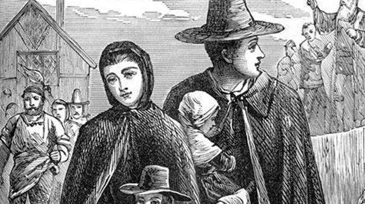
When the first Puritan colonists arrived here in 1626, the land, lakes, and rivers in our area were collectively owned by the Indigenous family group known as the Agawam people. With the exception of burning fields to plant corn, tribes relied solely on the seasonal but bountiful produce of the land, rivers, and ocean. The Native Americans were unfamiliar with the English concept of land ownership when in 1634, John Winthrop Jr. purchased all of the traditional Agawam land, stretching from Salem to the Merrimack River from the sachem Masconomet for the sum of £20.
Founded as a trading company, the Massachusetts Bay Colony was self-governing, treating its charter as if it were the constitution of an independent state. The Massachusetts Bay Company was set up as a joint stock venture. Any man contributing £50 to the venture was promised 200 acres of land. By 1642 the town of Ipswich and the general court handed out 9000 acres of land, leaving 3000 acres in the common pastures and 7000 acres ungranted.
In the commons, the early Massachusetts towns adopted English institutions of land management that often predated their own experiences in the mother country, reproducing medieval systems whose roots dated back several centuries. Shares of the Commons were granted, sold, and willed by freeholders, while newcomers to the towns were increasingly barred. Disagreements over usage and division of the common lands consumed the business of the towns, which responded with increasingly stringent measures to establish rules and enforce conformity.
Image from “Medieval Times”, courtesy of Google Classroom
During the Great Puritan Migration, Essex County was colonized by people from different regions of England who did not share a universally accepted concept of land ownership. Two major systems of pastoral land management existed in England in the 17th century. Settlers from central and northern England were still accustomed to manorial control over hundreds of acres for use by tenants who lived in the nucleated village. Shown above is an illustration of a manorial system with open fields where serfs farmed slender lots.
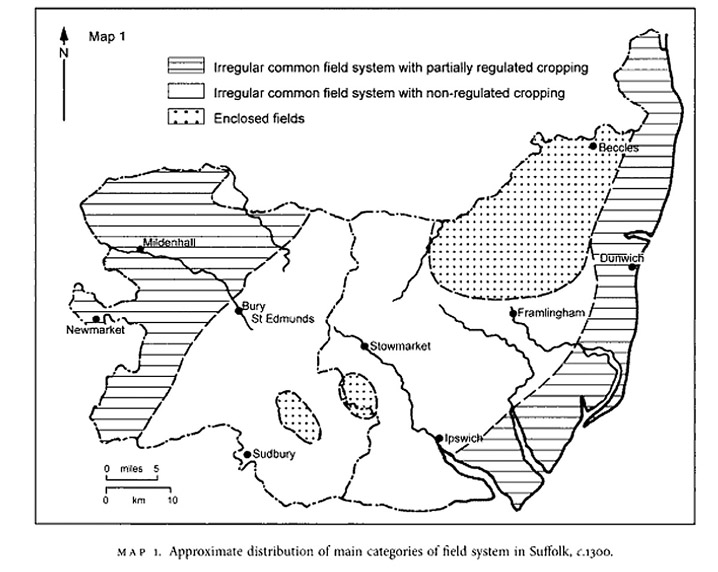
The settlers of Ipswich and Newbury came from southerly areas of England where open fields were disappearing and a closed field system had become dominant, in which formerly open fields were fenced and deeded to individual owners. This is an illustration of open fields in Suffolk County England, of which Ipswich UK is a part, in 1300. Image courtesy of the British Agriculture History Society
This second illustration shows Ipswich, Suffolk County in 1550, where enclosed fields had largely replaced the common land system.
The brief Puritan experiment in Massachusetts reproduced the names of English towns, and a hybrid model of medieval land tenure, granting huge farms to the favored and elite immigrants while allocating small house lots to ordinary people, who received tillage and animal husbandry privileges in the large fields beyond the Common Fence that surrounded the settlements. Individually owned land was treated as capital, as it is today, but common land was shared and used, not owned. Cattle and other animals of a given community grazed on portions of the arable land that were not currently bearing crops. The privileges of cutting wood in the commons, harvesting hay, and damming the rivers were strictly controlled by the towns.
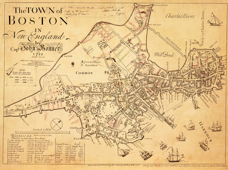
Boston Common: The 1722 Bonner map of Boston shows the Common, which as early as 1646 had become overgrazed, and the town was forced to place restrictions on the animals pastured there. Ipswich, Rowley, and Newbury with their extensive meadows and marshland were selling tons of salt hay and “hundreds of beef quarters” to the merchants in Boston. Image from Digital Commonwealth
Titles of Respect and Ownership
Mr. or Master: the highest-ranking man. Their wives were addressed as Mrs. or Mistress.
Freeman: Men who had taken the freemen’s oath.
Goodman: Men who had no other titles. A goodwoman, or “Goody” was the wife of a goodman.
Freeholder: a man who owned land.
Yeomen: one who owns and cultivates land (farmer).
Commoner: a person with rights to the common
Outsiders
In the first year of its settlement, the freemen of Ipswich established “for our own peace and comfort” the exclusive right to determine the privileges of citizenship in the new community, and gave formal notice that “no stranger coming among us” could reside, even temporarily, without their permission. The towns were further able to weed out undesirables by denying them commonage. Inhabitants who had a share in the common pastures sought to limit further distributions of rights to the commons. In 1659 the General Court ruled that no house erected after that year would have any right to common lands without the express consent of the towns, and authorized the towns to demolish and remove the dwellings of unapproved persons.
Great Neck
Before the arrival of the Puritans, William Jeffrey held the right to use a coastal drumlin in Ipswich which today bears his name as a fishing stage. Because he was not a member of the Puritan community, the General Court paid him to leave, and in 1639, the town of Ipswich set aside all of Jeffreys Neck as a common pasture. In the 1650s, the towns of Ipswich and Newbury intentionally developed their sheep industries, with mandated workforces of shepherds and wool spinners. By 1662, there were four hundred sheep on Great Neck, which came to be called the “Ram Pasture.” The common fields on the south side of Ipswich became so burdened with sheep that a hundred were transferred to the north side of town to graze with the cattle. In 1702 the common lands were divided into large sheep pastures. Keeping cattle and sheep on the Necks and the hills surrounding the town continued into the early 20th Century.
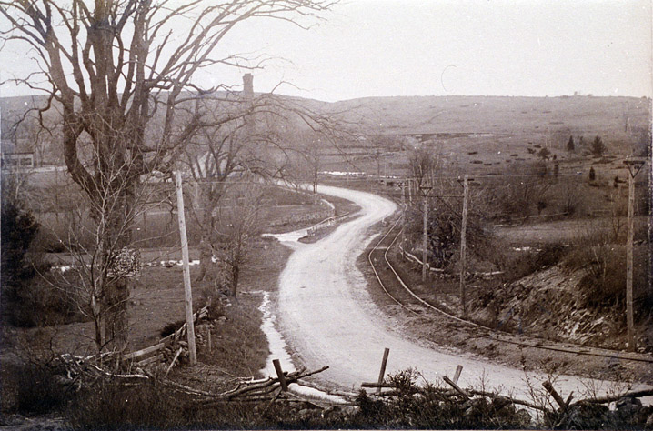
North of the gate at what was then the end of High St. was the great North Common Field. This photo of trolley tracks following High St. in Ipswich was taken in the early 1900s.
The “Inner Common of the South Eighth”
South of the Ipswich River was today’s South Green where cattle were herded in the mornings to the Heartbreak Hill common pasture, or further south to the Wilderness Hill common which is today’s Donovan Reservation. The area bounded by County Road, Essex Road, Candlewood Road, Fellows Lane, and Lakeman’s Lane was a part of the common land of Ipswich. When the common lands were divided into eighths in 1709, this area became known as the South Eighth. It included Gould’s Pasture, Ringe’s Pasture, Walker’s Island, and a pasture known as the Inner Common of the South Eighth.
Early land distribution and common fields in the “South Eighth.” Illustration from Publications of the Ipswich Historical Society Volume XVI Candlewood, an Ancient Neighborhood in Ipswich by Thomas Franklin Waters, with common land highlighted.
Today’s Argilla Farm and Maplecroft Farm are part of the huge farm that was granted to John Winthrop Jr. The land shown in white in this illustration was common land in what was known as the South Eighth. Greenbelt’s Donovan Reservation and Sagamore Hill in Hamilton were once part of the Ipswich South Eight Commons.
The rich soil on the south side of town also produced a scattering of large elite family farms in Candlewood and Chebacco. Appleton Farms remains the oldest continuously operating farm in America. Unapproved private enclosure of fields on the south side of town became a frequent issue of contention, and in 1649 the Town ordered the “restraint of inner fences.” The gentlemen farmers, the Symonds, Denisons, Hubbards, Whipples, Fellows, and Appletons, practiced individual agricultural ownership and management, and by the 1650s were no longer participating in communally managed herds. Established in 1638, Appleton Farms is one of the oldest continuously operating farms in America.
Topsfield
Early land grants in Topsfield MA
Topsfield, which was formed from parts of Salem and Ipswich, was initially granted in large parcels as reimbursements to wealthy supporters of the colony. In 1643 the Court granted Misters Endecott, Bradstreet, Symonds, Whittingham, Paine, and others of Ipswich and Salem the liberty to settle a village. The wealthy proprietors divided their lands and induced individuals, many of whom had settled first in Ipswich, to purchase parcels, recovering far more than their initial investments. A list of 31 commoners was recorded in 1661, and over the next 60 years in three separate divisions, the Topsfield common land was divided among themselves or their descendants by inheritance. Several proprietors acquired large farms by receiving abutting shares three times.
View of Mt. Pleasant from Town Hill in Ipswich. Photo by Edward Darling c. 1900
At about the same time, the Town of Ipswich expanded the grazing fields to the hills along Topsfield Rd. On March 15, 1651, complaints were made to the Ipswich selectmen “that the inhabitants of Topsfield do with their cattle feed on our cow common to the great prejudice of the Town herd.” They replied that if any of their cattle were found “feeding upon the cow commons of Ipswich, they shall be acknowledged to be trespassers, and the owners of them bound to make satisfaction.”
Fences
Town Hill looking out at Castle Neck in Ipswich, Cyanotype by Arthur Wesley Dow, ca 1900
When the settlers arrived, many of the hills had already been cleared by the Indians, and the felling of trees was of great concern from the start. In 1639 it was decreed, “No man shall fell any timber without leave from the Constable, under penalty.” A special license from the Selectmen was required before any white oak could be felled on any house lot or in the commons. The felling of timber on Jeffrey’s Neck, Castle Neck, and Hog Island was prohibited in 1650.
Ipswich parishes and land use in the 17th & 18th Century
In Ipswich, every man who built and owned a house became forthwith a commoner and had rights in the common land. Tillage lots of about six acres of commonage were assigned to each householder, and a fence separated them from the “Great Cow Common.”
Residents who owned privileges in the common were to maintain the fence in proportion to their allotments. The town of Ipswich voted in 1637 that “a general fence shall be made” extending from the west end of the town to the Egypt River (today’s Rowley River), from the east end of the town on the way to Jeffries Neck, and on the south side of town from Heartbreak Hill to County Rd. Every morning great herds of cattle were driven out to forage in the woods. Men known for sobriety and carefulness were chosen for the important role of fence viewers. Originally, only grazing was allowed outside the common fence until the privilege of planting crops on Great Neck was granted in return for planting hay, a successful experiment that resulted in tillage privileges being granted throughout the commons.
Newbury
The Lower Green in Newbury MA Old Town
In 1635, the Rev. Thomas Parker led a group of about 100 pioneers from Wiltshire and Hampshire in southern England to found the town of Newbury. House lots, planting lots, marsh lots, and meadow lots were granted and laid out, and a quarter of the freemen of Ipswich decided to move and join their settlement. A house lot of four acres, with the right of pasturage, was assigned to the poorest settlers. Fifty acres were allotted to any persons who paid for their own transportation to New England. Two hundred acres were granted to every family that contributed fifty pounds to the common stock. The tiny settlement on the Parker River was surrounded on three sides by 3800 acres of salt marsh, and in 1645, the entire town relocated north to the Merrimack River to take advantage of more arable land. They maintained an open field at their earlier location, known historically as the Old Town Pasture where cattle grazed.
Sheep were watered in the new location in Newbury at a kettle hole they named Frog Pond, now in Newburyport. Photo courtesy of the Historical Marker database
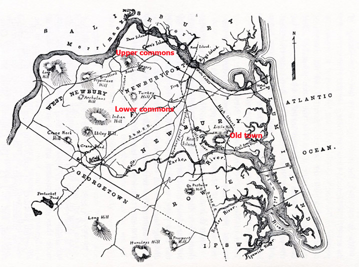
The Newbury Upper Commons included most of the land now in West Newbury, extending from the Artichoke north to the Merrimack River, and were used primarily for milk cows and other livestock in active use.
The Lower Commons was in today’s Newbury, south to the Rowley line, excluding over 2000 acres granted to Richard Dummer, Henry Sewall, and others at Newbury Falls, now called Byfield Parish. The two commons together comprised about 8000 acres. In 1641 the Newbury freeholders voted to divide the common lands closest to the village into three equally divided separate pasture areas, the cow common, the ox common and the heifer common, and the cattle were divided accordingly. For eight months of the year, the herd grazed during the day and was brought to the village common at night by the herdsman.
The freeholders of Newbury ordered, “that fences shall be made and always kept so sufficient as to keep out all manner of swine and other cattle great or small.” An order in 1653 required freeholders to maintain the fences in good order,” made of pales well nailed, or of five rails well fitted, or of stone 3½ feet high minimal, or a ditch 3-4 ft. deep with two rails, on penalty of a fine.” During the winter, the fence rails were knocked down, and horses and cattle were allowed to run at large in the commons and on Plum Island, where ditches were dug to drain the marsh for the ease of cattle.
Stints
Stinted fields, closes & common pastures. William R. Shepherd, Historical Atlas, New York, Henry Holt and Company, 1923
All land owners were entitled by grant, purchase, or inheritance to own shares in the common and undivided lands, and operated the affairs of the Commons as an independent body of freeholders. Not all commoners were freemen; only those who had taken the freeman’s oath were allowed to vote in the town’s affairs. Five hundred and sixty-three stints in each Newbury pasture were divided among the freeholders in proportion to the number of shares owned by each.
Stints, often called cattle gates, were used in medieval open field systems to balance the number of stock animals with the capacity of the land and prevent overgrazing. In Newbury, Richard Dummer, despite owning a farm, received 62 stints, while the two poorest men received only one. In 1642, the freeholders of the town decreed that the number of stints they had allocated the previous year “shall perpetually belong to the several persons to whom they are allotted and to no other persons whatsoever, except he gets them by purchase or some other legal way.”
Rowley
Rowley was created from parts of Newbury and Ipswich in 1638.
In 1638 parts of Newbury and Ipswich were granted to Rev. Ezekiel Rogers, who led a group of immigrants from Yorkshire in northwestern England who were still familiar with an open field system. The farmers along upper High St. in Ipswich shared a close geographical and social relationship with Rowley and tended to stay longer with communally managed agriculture.
In 1649, The General Court decreed, “Upon the petition of Newbury, this court gives and grants Plum Island to Ipswich, Rowley & Newbury, with Ipswich to have two parts, Newbury two parts, and Rowley to have one-fifth part.”
House lots were granted to the early settlers of Rowley MA, but only a handful of large farms were granted. Every person in town was entitled to receive two acres for every 20 shillings he had paid in the “last country tax.”
In 1643 it was ordered, “that all the commons which belong to the town of Rowley, shall extend five miles from the town every way, where the town has property, which shall not be laid out to any particular person. It was agreed that every 1 1/2 acre house lot would have 1 1/2 gates in the common pastures. The apportionment rose exponentially so that a 6-acre house lot would have 45 gates. The use of the term gates instead of stints is another indication of how the settlers of Rowley had different open-field traditions. Records from the Probate and Quarterly Courts indicate that the commoners of Rowley had their own gates, instead of the common gates that were used in other towns. The town had authority to order any man to work in the common, and refusal to do so would result in a fine for every hour that he failed to appear.
Conversely, Ipswich adopted a principle of one house lot receiving one commonage, and in 1641 the freemen of the town voted that the Selectmen should no longer “meddle with further stinting of the common.”
These two large stones on the side of Central Street in Rowley just before Townsend Brook are said to have been placed in 1639 at the entrance of Common Land of the First Settlers of the town. The brook is so named because it was the “town’s end.” This point was designated as the northernmost boundary in the early settlement of the town. Photo from the MACRIS site for Rowley
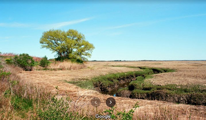
Salt Marshes
Nelson’s Island in Rowley. The salt marshes at Plum Island and in the Parker River estuaries produced abundant quantities of two types of hay used for cordage and feeding livestock.
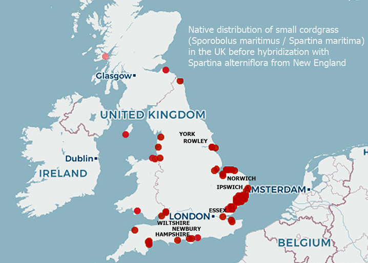
Native distribution of small cordgrass in the UK before hybridization with Spartina alterniflora from New England
The settlers in Ipswich and Newbury, and to a lesser extent Rowley, came from coastal areas of England and were familiar with small cordgrass, traditionally known as Spartina maritima, which is the only salt marsh cordgrass native to England. It took years to cultivate English hay, but the native salt hay Spartina alterniflora (aka Sporobolus alterniflorus) was already here for the taking. Over the years, a hybrid of American Spartina alterniflora with the native English cordgrass has become dominant in the U.K., while the delicate Spartina pattens which is eaten by cattle became highly invasive in the Mediterranean and the American West Coast.
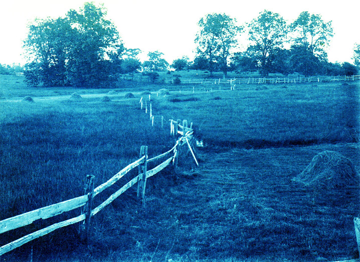
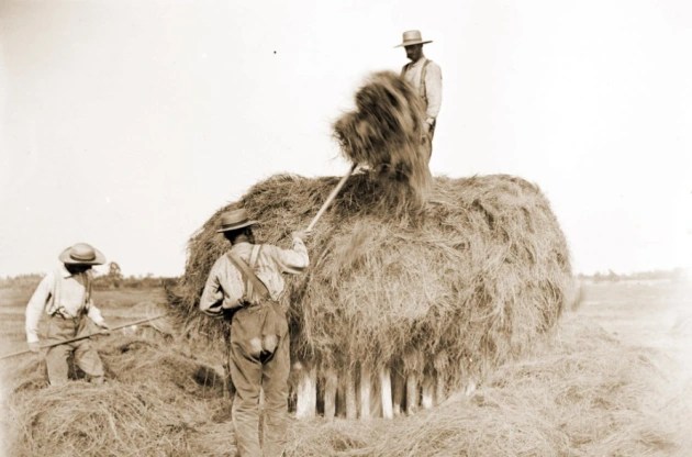
Stacking hay on staddles
Marsh hay was harvested and shipped to the larger communities, including Boston where it was unloaded at Haymarket Square. A load of salt hay and thatch could be sold for a considerable sum, and the privilege of harvesting it was sold or auctioned annually by the towns. For over 200 years, the seasonal harvest of salt hay on Plum Island was a communal ritual, of cutting, stacking, and transporting the hay.
Painting by Fitz Henry Lane. Flat bottom boats known as gundalows unloaded salt marsh hay at the town landing, Nelson’s Island in Rowley, and at Green’s Point in Ipswich. According to historian Joshua Coffin, Plum Island produced 2800 tons of salt hay in 1840
In 1645, Thomas Tuck charged that “Richard Moore made a well upon the common for his own use the last summer, being very dry and water scarce upon the Neck. Tuck hired a cow, which came to drink at the well, and the water being very low the cow broke her neck.”
In the case of William Sargent v. Samuel Bushwell in 1653, for a cow “that was killed by a beast belonging to the defendant. Agreed that the plaintiff shall have half the price of the living cow and that the hide of the dead cow as appraised by town men shall be divided between them”
In 1662, in the case of Samuell Plumer vs. Charles Brown for trespass and taking up a heifer of his from Newbury Neck, John Hopington deposed that two years ago last Michaelmas, Charles Brown lost a black heifer, and at the same time there was a beast killed at a place called “the straits as we go to the rye field.” He heard Browne’s wife say that she feared it was their heifer. Thomas Hale Jr. deposed that the heifer came of a black cow which he sold to brother Lambert and that she was a very poor calf. He put her in the Rowley dry herd and she had the same ear-mark as his other cattle. Andrew Heddan testified that after the heifer was put into the dry herd, he told Charles Brown’s wife that he saw the cow in Rowley Common field upon John Harris’s ground and that at midsummer this heifer left the dry herd, came to the town and went with the cow herd, keeping constantly about Charles Brown’s yard.
In Ipswich Quarterly court, July 22, 1664, Daniel Black filed a complaint against his wife Faith, for keeping company with Judith Trumbull and John How, and sometimes being in bed with John How, and that he was a poor man and had nothing to live by but his labor and one cow, and for the want of the miking of the cow, he lost the profit because of his wife’s carelessness, by which he was provoked several times, often threatening her. John How testified that he heard Daniel Black “wish to God to damn his soul if he did not beat his wife’s brains out.”
Managing disputes like this was a burden to the selectmen. On May 7, 1659, the selectmen of Rowley ordered, “considering the great oppression of the cow commons by horses, mares, yearling colts and dry cattle that are not driven into the dry herd commons; that all inhabitants having more than one horse or mare shall drive their yearling colts and dry cattle into the dry herd commons within three days after the publication hereof upon penalty of 5s. The selectmen of Newbury ordered, May 14, 1663, “that all the dry cattle, except working oxen and yearlings, shall be driven up out of the cow commons.”
Dissension in the Commons
From the earliest times, there was resentment in Ipswich that some commoners weren’t fulfilling their obligations. Furthermore, it was complained that cattle from Newbury were tramping down the salt hay and it “would be the ruin and utter destruction of the whole island.” The division of the commons in Ipswich began in 1664 when the town voted that Plum Island, Hog Island, and Castle Neck be divided among the 203 inhabitants who had the right of commonage. Eight-acre lots of valuable salt marsh were provided to the 28 wealthiest men, while the poorer men received four, primarily in the upland lots. Adjustments were made for those who had been overlooked or “fell short of their due proportion” and for many years the town continued to issue corrections.
Late 19th-century photo of hay on staddles by George Dexter
The Ipswich committee reported in April 1665 that there were 800 acres of marsh and upland on Plum Island, “beside beaches and gall’d hills.” Thatch banks and clam flats remained the property of the town and were let each year to the highest bidder, with only commoners having the right to bid. Hogs, horses, and cattle were kept on the island during the winter, ruining the marsh grass, and in 1739 the General court banned the practice. Today’s protected salt marshes and clam flats, with strict control of shellfish permits, are vestiges of preservation measures taken in the 17th and 18th centuries.
Restrictions on the number of freeholders were decreed in several towns but became problematic to enforce as the population grew. In 1660, individual lot grants were given in the Newbury and Ipswich Commons under the condition that the recipients would clear the land, fence it, and plant at least 4 bushels of English hay per acre. At the end of six years, the land would revert to being a common field. In this regard, land was intrinsically tied to its use rather than outright ownership, a concept shared by the indigenous people of America and in medieval England.
In 1683 the whole of the Newbury Lower Commons was divided into five “sheep walks.” Historian Joshua Coffin estimated a total of over 5,000 sheep grazed the pastures. At this time much of the land above the Artichoke River was still common, unfenced, and unimproved, although large quantities of lumber were being taken.
In the late 17th Century, the Newbury commoners became increasingly alarmed that their hereditary advantage was disappearing. At a meeting of the freemen and freeholders in 1684, it was voted that 6000 acres of the Upper Common would be lotted out, with only 1000 acres going to non-freeholders, and that “this shall not be a precedent to the future in the ordering or dividing of any other part of the common.” The total number of freeholders was based on the 1642 vote of 91 freeholders “and no one else.” The non-freeholders objected that they paid the same taxes as freeholders and should have the same rights. In 1686 the allocation was altered, with half going to freeholders, and the other half going to other freemen who were up to date on their taxes. Those who paid more in taxes received larger shares, with the locations of the allocations determined by drawing names out of a bag.
The old Sawyer farm, which later became the Moseley estate and is now Maudslay State Park in Newburyport
In January 1701, the freeholders of Newbury voted to divide the majority of the Lower Common, comprising 1,800 acres, while reserving pasturage for the town’s ministers and free school as well as for the benefit of the town’s poor. The wood remaining on the common land was measured and divided among the freeholders and inhabitants in 1701 and again in 1708.
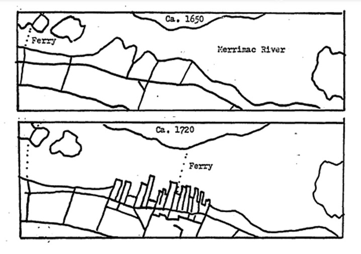
Between I703 and I705 the remaining common lands bordering the Merrimack River were divided into 224 lots and were distributed or sold by the proprietors. The allocation of private lots with frontage on the river for private use resulted in a rapid expansion of the shipbuilding and fishing industries, the establishment of an additional ferry, and the construction of new waterfront streets.
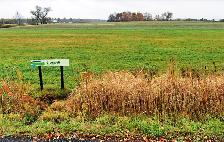
The 47-acre Wet Meadows conservation area on Scotland Rd. in Newbury. Image courtesy Essex County Greenbelt
The marshes on Plum Island were for many years retained by the commoners. Ditches were dug to drain the marsh for cattle, and later to mark individual lot boundaries. Finally, at a meeting of the proprietors of the Newbury common lands held in 1827, the standing committee was instructed to sell at public auction “all the lands belonging to the said Proprietors in the town of Newbury, and conveyed for the sum of six hundred dollars to Moses Pettingell, of Newbury, “that part of Plum Island lying & situate in said town of Newbury, containing twelve hundred acres, more or less.”
The northern end of Plum Island, 1827-1883
Pettingell made a tidy profit from the sale of Plum Island’s timber and sand, and the size of his holdings grew unexpectedly when the Merrimack River channel shifted to the north in the mid-19th Century. In 1920 the Plum Island Beach Company purchased the Newbury section of Plum Island from the Pettingell family, constructed Northern Blvd, and divided the land into lots for sale to the public.
Division of the Ipswich Commons
In 1660, the Ipswich Selectmen petitioned the General Court that the town had become burdened by the multiplying of dwelling houses. The Court ordered that no house henceforth erected shall have any right to the common lands and applied it to all towns, which responded by drawing up two lists, one of the number of original commoners, and a second of whom among them still had rights to the common. Those who had moved to their farms would no longer have commonage. A pressing issue was that wealthy farmers who already had commonage were passing their farms to their sons and retiring to their houses in town, a threat to the “one man one commonage” rule. Did commonage belong to the individual or could it be transferred along with sales of property?
Approximate locations of the 1709 division of Ipswich common land into eights as copied from town records. The map is “The Plan of Ipswich” by Barnabas Dodge, dated 1794-5 (includes Chebacco Parish.)
Resolving continuous disputes regarding cattle and sheep was burdensome for the Ipswich Selectmen, and as the 17th Century ended, men began boldly asserting sovereignty over their allotments. The scarcity of new productive land to expand the commons system convinced the towns’ leaders as well as the proprietors that the common fields should be distributed permanently.
In 1709, a list of old and new commoners was agreed on, and the remaining 5850 acres of common land, about 9 square miles of common lands were divided into eight parts with two-fifths going to descendants of the original settlers and three-fifths to more recent commoners. Three further divisions occurred, the last being in 1720, including 900 acres in Chebacco, which is now the Town of Essex. The land could now be rented or sold. Price controls were attempted but several men became rich investing in commonage.
After the Revolutionary War, the State of Massachusetts enacted various measures regarding commons, setting rules for meetings, fencing, taxing, and trespassing, in an attempt to stabilize the Commons system. Finally, in 1788, the majority of the Ipswich commoners voted to resign all their interests in the remaining common lands toward the payment of the heavy town debt incurred during the Revolution, a grant estimated to be worth about £600.
In Ipswich, Great Neck continued to be held as common land by a group of men who organized as “The Proprietors of Jeffries Neck Pasture.” The 1832 Philander Andersen map of Ipswich shows a “Neck gate” for cattle. View the entire map at Digital Commonwealth.
Bush Hill between Topsfield Rd. and Pineswamp Rd. was still used as a defacto common as late as 1900. Today’s lot lines were created when the open fields were divided. Circa 1900 photo by Edward Darling.
Cows on today’s Jeffreys Neck Road in Ipswich. Great Neck was used as commercial pasture land until the early 20th century when Alexander B. Clark bought up all the lots. Photo by George Dexter, early 1900s
Husbandmen became independent farmers on the outside of the town’s center. The agricultural commons ceased to exist, but today’s South Green in Ipswich was where cattle were once corralled, and later became the Town’s training ground. Circa 1915 photo, courtesy Ipswich Museum.
Late 19th Century photo by George Dexter of grazing fields on the coastal drumlins in Ipswich
Division of the Rowley Commons
Plan of Rowley surveyed by Joseph Chapin, dated December 1794. Photo courtesy Digital Commonwealth, with enhanced colors indicating “large tracts of unfenced “barren and unimprovable land.”
In 1673-4, almost a decade after Ipswich and Newbury began dividing out their commons, it was agreed by the town of Rowley that two-thirds of their town commons should be divided out to the proprietors in proportion to the number of gates they owned. Unimproved remnants of the common fields persisted into the 18th Century. In the 1794 Plan of the Town of Rowley, the publisher noted that “there are large tracts of barren and unimprovable land whose owners determine that they are not worth fencing. Some of these lands are marked in yellow.”
In 1622, eight years before the establishment of the Massachusetts Bay Colony, Capt. John Mason had obtained title to all the land from Salem to Newburyport as a principal partner in a stock company known as the Plymouth Council for New England. In 1681, his grandson John T. Mason presented a letter from the King to the General Court, which ordered “all said tenants” to appear in the Ipswich court. If his birthright claim was confirmed, every land title would be worthless and Mason would have been able to impose a medieval manor and tenant land system. Eventually, his case failed, after causing extreme anguish among the populace.
Tercentenary Commission Marker on North Main St. in Ipswich. The revolt against Governor Andros was about taxes and land.
Then in 1686, Governor Andros imposed a 2.5 shilling quit rent per annum on all 100-acre lots not occupied, or occupied with defective titles. Since all of the existing land titles in Massachusetts had been granted under the vacated colonial charter, Andros essentially declared them void and required landowners to recertify their ownership by paying fees to the Dominion as a quit-rent. To strengthen their title, the Selectmen of Newbury, in consideration of £10 purchased the entire town of Newbury from Samuel English, the surviving heir of Masconomet, constituting about 10,000 acres. The threat ended when news reached Boston of the overthrow of King James II, and Andros was arrested by a mob that descended on the city.
Further Afield
Each town developed its own standards for allocations and divisions. In Salisbury, the lot that one received was based on what he was worth. The settlers of Gloucester replicated their customs from western England, where fishing was the primary industry and enclosure was well advanced. In Haverhill, John Ward and his followers doled out 20-acre house lots to themselves, leaving common land mostly along its periphery, and by 1659 its open-field structure had disappeared.
Andover retained its open-field system longer than the older towns established by people from the east and south of England. Today’s North Andover was the center of the original town of Andover, MA. The common fields were in the south part of town, which is now the town of Andover. The Trustees of Reservations’ Ward Reservation is on land that was part of the common fields.
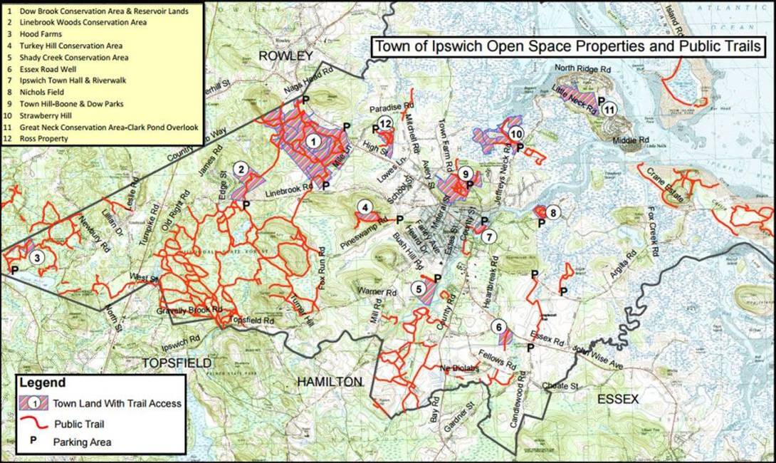
In the spring of 2000, the Ipswich Town meeting authorized a $10 million Open Space Bond for the protection of land for open space, water supply protection, and recreation, preserving the land from development. The town’s investment adds to Willowdale State Forest, Plum Island, Appleton Farms, and Crane Beach, which are preserved by the State and environmental organizations.
The Dow Brook Conservation Area on the north side of Ipswich is the primary source of the Ipswich public drinking water supply and provides quality wildlife habitat within a regional greenway of over 3,000 acres. Public access to the property is located in a parking area next to White Farms Ice Cream on High Street, near the Rowley town line.
Part of the Ipswich Open Space program, the Great Neck Conservation Area property adjacent to Clark Pond is a remnant of the common field where livestock were kept in the summer. The Town acquired the 85.5 acres in 2007 for the protection of highly sensitive coastal wetlands and wildlife habitats.
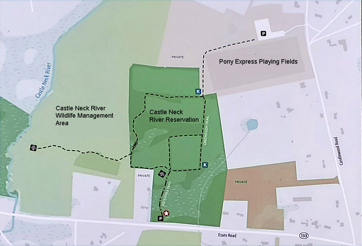
The Ipswich Pony Express youth soccer fields, Greenbelt’s Castle Neck River Reservation, and the Castle Neck River Wildlife Management Area are on land that was granted to early Ipswich settlers John Fawn, John Perkins, and Thomas Howlett, adjoining the large commons in the “South Eighth.”
The Ipswich Pony Express fields before they were purchased by the Town of Ipswich and Essex County Greenbelt
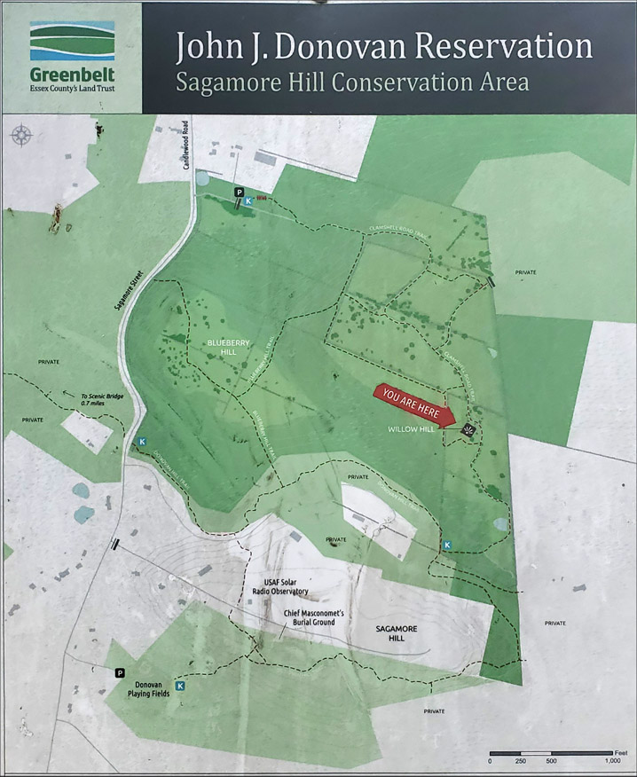
South of the Pony Express Fields are Essex County Greenbelt’s John Donovan Reservation and Sagamore Hill. Although now in the town of Hamilton, it was originally part of Ipswich.
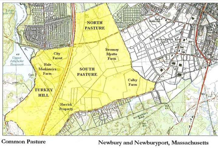
This excerpt from the 1830 map of the original Town of Newbury still showed a Common Pasture near where Newbury, Newburyport, and West Newbury meet between Turkey Hill and the Little River.
Image courtesy City of Newburyport
The Common Pasture located in Newbury, Newburyport, and West Newbury, is a remnant dating back to 1635. The entirety of the present-day Common extends from north of Hale Street in Newburyport, crosses Hale St. through the City to Turkey Hill Road in West Newbury, then follows Scotland Road in Newbury and abuts the Little River Nature Trails on the eastern branch of the Little River. The City of Newburyport, the Town of Newbury, the Trust for Public Land, Essex County Greenbelt Association, and the Parker River Clean Water Association have worked together to protect key portions of the Common Pasture through land acquisition and agricultural preservation restrictions.
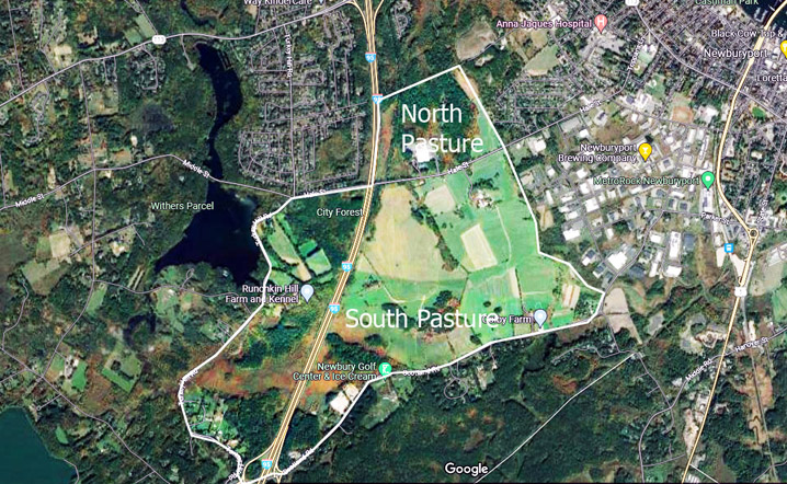
Satellite view of the Newbury/West Newbury/Newburyport common pastures.
In 2006, the City of Newburyport and The Trust for Public Land (TPL) announced the acquisition and permanent protection of the 102-acre North Pasture property on Hale Street in Newburyport. The North Pasture today comprises about 240 acres, extending to the Little River. A trail system winds through the Cooper North Pasture. The South Pasture area is zoned agricultural/residential and contains the largest concentration of farms remaining in Newburyport. Scotland Road delineates the southern boundary of the South Pasture. The land along the south side of Hale Street from Route 95 east to the Little River comprises the northern portion of the South Pasture. The Turkey Hill area includes land west of Route 95 that was historically part of the lower common in Newburyport and West Newbury.
Allen, David Grayson, In English Ways,The Movement of Societies and the Transferal of English Local Law and Custom to Massachusetts Bay in the Seventeenth Century.
Fischer, David Hacket: Albion’s Seed, Four British Folkways in America
The Capt. Joseph Gould House is an enigma; a substantial early 18th Century house constructed in at least two stages, and the only First Period house in our area believed to have been constructed two rooms deep (aka bays or piles) deep. The 1710 Gould Barn that once sat on this property was dismantled and reconstructed at the foot of Howlett St.
The three-bay east side of the house is the oldest, and the house achieved its present appearance when the left side, also of three bays was added c. 1725. Typical of the period, the spacing of the windows is irregular, although most are vertically aligned. The chimney on the right original side is more substantial, and the fireplace below it in the downstairs room is the largest in the house. The roof is of substantial principal rafter and common purlin construction on the two sides of the house. In addition to the depth of the house, another transitional feature is the eaves, which appear to have originally featured a plaster cove.
Inside the house, framing is doubled at the junction of the earlier and later sections and is exposed in several rooms in both sides of the house. Transverse summer beams (instead of longitudinal) are on both sides, measuring 11 1/4″ in general, featuring flat chamfers with “lambs tongue” taper stops. Summer beams in the upstairs of the west side are unchamfered. Story posts in the rear section are elaborately molded, similar to several houses in Salem. Simpler gunstock posts are found in other rooms. Downstairs in the entrance and rear room west (later) part of the house, posts and beams have narrower flat chamfers and simple triangular taper stops. Measurements for the joist spacing is about 25″ on center. A reused chamfered summer beam can be seen in the cellar.
Conflicting studies
The MACRIS listing and nomination papers for the Joseph Gould house state that the oldest section was always two rooms deep and dates to before the 18th Century.
The “Old House Whisper” John Cole and Eleanor Bailey studied the house and wrote that the earliest part was an over-room “half house” structure built for Joseph Gould about 1712 at the time of his marriage to Priscilla Perkins. Cole observed a reused summer beam in the basement and believes the house was expanded to the west and in the rear around 1751 at the marriage of Joseph Gould 2 to Elizabeth Emerson. He does not, however, reconcile the preponderance of First Period (pre-1725) architecture throughout the house with the mid-18th Century.
Abbott Lowell Cummings is known to have visited the house but his notes and observations have not been discovered.
Kari Ann Federer did a comprehensive study of the house in 1989 which is copied in part below.
Rear, Capt. Joseph Gould house. The left side in this photo is believed to be the older half.
The Joseph Gould House and barn
Kari Ann Federer, Boston University, December 18, 1989 (excerpt)
INTRODUCTION
This is a study of two late first-period buildings in Topsfield, Massachusetts, the Joseph Gould House and the barn which stood on the property, until it was dismantled in 1983. Both house and barn were constructed in two phases, the second doubling the original in size and following its plan and form quite closely.
The resulting six-bay dwelling was essentially two end chimney houses built back to back, with chimneys up against each other, creating something like a central chimney house. The barn totaling nine bays, consisted of two classic five-bay barns side by side with one bay overlapping.
This double house and a double barn existed by the mid-1700s and were occupied, at that time, by two different, though probably related families. Traditionally, the older half of the house was said to date prior to 1700 and the second half shortly thereafter. The popular tale was that the later section was added to make the house into a duplex for father and son. However, research into deeds and probate records has suggested that both of these traditions are inaccurate.
This study is an attempt to shed light on the history of the Joseph Gould farm by examining the original framing and construction of the house and the barn, as well as the overall layout of the farmyard and the changing uses of these spaces.
PHYSICAL DESCRIPTION OF THE JOSEPH GOULD HOUSE
The eastern half of the Joseph Gould house was the first portion to be constructed. It was initially an end chimney house, two and a half stories high, one room wide and two deep, with the chimney at the west end of the dwelling. The house measured twenty-seven and a half feet wide and twenty-eight and a half feet deep. The rear rooms were about two-thirds as deep as the front ones.
The Gould house is now covered in clapboards, attached with wire nails, which must all be replacements. However, the original house would also have been sheathed in unpainted clapboards. The roof cornice overhangs about a foot along the front of the house and diagonal boarding is said to cover a plaster cove.
The nine-over-six sash windows on the Gould house are later eighteenth-century replacements. The current configuration of this eastern section of the house is not original, as the chimney has been moved to the east and a room was created in what had been the chimney bay. Evidence of this alteration includes Federal mantels on the fireplaces of the southeast rooms upstairs and down, as well as the fact the transverse summer beams were off-center in these rooms lying closer to the chimney wall than would be expected.
Due to this alteration in the chimney bay of the Joseph Gould house, no evidence of the original entry door, staircase, or fireplaces can be seen. It might be assumed that the configuration of the chimney bay was fairly typical of the late first period. In New England houses of the First Period, the staircase and entry were usually combined, with the stairs rising up across the front of the chimney.
The staircase from the first to second floors of the Gould house may have been a straight run composed partially of winders. The open balustrade, with turned balusters and molded hand railing, would have housed within a closed string.
Under the stairs would have been molded vertical sheathing and perhaps a door to the cellar stairs. However, a trapdoor to the root cellar currently exists in the northeast corner room of the house and there is no reason to believe this is not its original location.
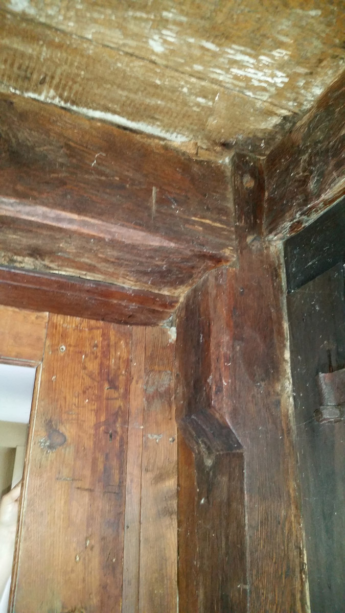
In this first half of the Joseph Gould House, the frame would have been entirely exposed, though some members are now boxed. All summer beams are transverse and these timbers are continuous from the front to the back of the house, proving that both stories were always two rooms deep. Joist spacing in this part of the house, is twenty-five inches on center; a measurement consistent with the late first-period date of the house. Where visible, all summer beams and girts have flat chamfers with lambs tongue stops except for those of the chimney girt in the rear room, which have triangular stops.
As in many other houses with transverse summer beams, the most highly embellished parts of the frame are the story and chimney posts. These have elaborately molded heads with a deep quarter round and two fillets. It seems to be only the rear posts that are fancy, however. Most of the front framing members are now boxed, but the front chimney post can be seen, and this is much simpler with only a very wide flat chamfer on its sides. The rear corner posts are similar to this one, as are all visible posts on the second floor.
In the attic, one can see that both halves of the Joseph Gould house are constructed with a principal rafter, common purlin roof system. Each half of the house consists of four pairs of rafters, bridled at the ridge, creating two three-bay sections. On each slope of the roof are five purlins trenched over rafters, with the ridge purlin resting in a notch cut into the upper rafter. Massive long collar beams tie together the rafters in the older (eastern) half of the house. These ties, along with the rafters, are finished with narrow flat chamfers.
The rafters are doubled at the transition point between the two sections of the house. When the second half was added, another complete house frame was built up against the old one. Visible in the ridge between these two frames, are original clapboards from the exterior west gable end of the earlier house. The roofing system of the second half of Joseph Gould House is very similar to that of the first. The frames line up exactly, though the later section has slightly heavier purlins and no collar beams, but struts rising up from tie beam to rafter instead.
In plan, the second half of the Gould house copied the original. However, the west half is about six feet narrower, being only twenty-one feet wide. The basic configuration of this half of the house has not been altered. The five-foot wide western chimney bay is in its original location, though the chimney stack is now smaller than it would have been.
The stairs from the first to the second floor and also up to the attic, are still in their initial location in front of the chimney. The staircase is typical of the late First Period, with turned balusters, but a plain newel post. Molded paneling under stairs makes it clear that there were never cellar stairs there. A trap door to the root cellar also exists under this half of the house. The staircase was probably a double run with landing, originally. The current unusual configuration was most likely created when the chimney was rebuilt and narrowed. An empty space was left behind the chimney and it was logical to use this as an easier way to reach the rear chamber.
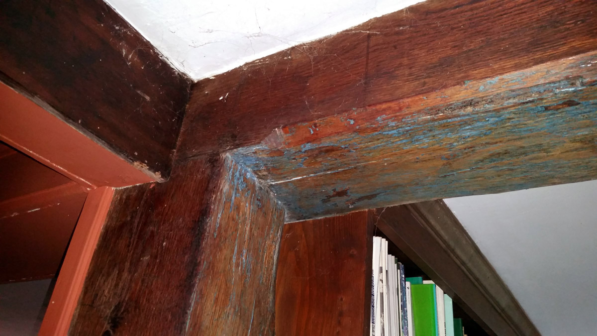
The summer beams are also transverse in this second half of the Joseph Gould house. Much of the frame is now boxed, but it is visible in the rear rooms, upstairs and down, and in the front entry. Typical of the less decorative embellishments of the end of the First Period, very narrow chamfers with taper stops can be seen in rear rooms. The rear-story post has a fancy molded head, similar to those in the older half of the house. However, all other posts in the rear room are simple with only very narrow flat chamfers on their sides. In the west front entry hall, the front chimney and corner post can be seen and these are very plain with almost no chamfers at all. Upstairs, the rear posts are undecorated and here the summer beam is the only chamfered member.
Sometime later in the 18th century, the frames in the west front rooms of the Joseph Gould house were boxed and the first-floor room was embellished with a corner cupboard. Some of the feather-edged panels on the fireplace wall of this room may date from the construction of the house, as this became very popular in the early 18th century. The raised paneling in the west front chamber may also be original. This type of decoration came into use by about 1725 and like other new fashions, was often tried upstairs in the chambers first.
Typical of the First Period, the Joseph Gould house was built facing due south, while the barn backed up to the northwest wind. This created a sheltered farm yard in front of the house and barn and later outbuildings added between the two protected it even more. First Period barns were often located in front of the house, closer to the road, to show off the family’s stock and store of supplies. As the location of man-made structures helped to bring coherence into a chaotic world, the forty-five-degree angle between the ridgepoles of the Gould house and barn enforced the disjunction between the artificial rational world of man and the irrational dirty world of livestock.
BACKGROUND OF THE GOULD FAMILY AND THE SETTLEMENT OF TOPSFIELD
The area which is now the town of Topsfield, Massachusetts was originally part of the seventeenth-century plantations of Ipswich and Salem. During the 1630s and 1640s, large grants of Topsfield land were given to Ipswich Residents. The land where the Joseph Gould house stands was part of the Captain Patrick Grant, which like many of these large land holdings, was soon divided and sold. In 1644, three hundred acres of it were purchased by Zaccheus Gould (1589-1668), who had arrived from England in 1639 and decided to settle in the newly developing community of Topsfield. Twenty years later, in 1664, it is estimated that Zaccheus Gould owned some 3000 acres, 580 in Topsfield and the rest in neighboring Boxford. At this time, Zaccheus sold his entire estate and house in Topsfield to his only son John Gould (1635-1710), who had come with him from England as a young child. John Gould lived in his father’s house, past which Washington Street was laid out late in the 1660s. He and his wife Sara (Baker), who were married in 1660, raised eight children, one of whom was Joseph, born in 1677.
CONSTRUCTION HISTORY OF THE JOSEPH GOULD HOUSE AND BARN
Although Joseph Gould is traditionally said to have built his original house prior to 1700, there is no recorded deed giving him land until March of 1709. At this time, John Gould, who was nearing the end of his life, divided his estate among his surviving sons. Joseph was given sundry parcels of upland, meadow, and woodland in Topsfield and Boxford. This deed was not specific about the boundaries or acreage of the property, but it should be noted that it did not mention any buildings on the land, nor does it indicate that Joseph Gould owned any of the abutting land previously.
In 1709, Joseph Gould would have been 32 years old, but still unmarried. It seems quite likely that the first half of his house was not constructed prior to this time. This conclusion is supported by a map of Topsfield printed in 1950 for the town Tercentenary, which labels the house “Abbott 1709” (Abbott being the owner at the time). This date also coincides with that which First Period barn expert Robert Blair St. George has assigned to the earlier half of the Gould barn.
In the process of establishing his own farm, Joseph Gould probably built the first halves of his house and his barn in 1709 to 1710. A few years later, in 1712/13, Joseph married 23-year-old Priscilla Perkins. The two immediately began a family, Priscilla giving birth to their first child in 1714. The Goulds had eleven children, but only six survived past early childhood. The only surviving boy being Joseph Gould (2).
The second half of the Joseph Gould house was traditionally thought to have been added to the west of the existing house, built between 1700 and 1720. Perhaps the latter end of this range is correct. No documentary evidence could be found for the construction date of this portion of the house. According to the probate inventory of Joseph Gould (1), it was certainly in existence by 1753. The features of this western end of the house are typical of the late First Period and thus it is unlikely that it could have been added any later than the 1720s. The second half of the barn was also standing by 1753 and Robert St. George felt it must date from between 1720 and 1750.
The traditional story tells that the second half of the Joseph Gould house was built to make a duplex for father and son. However, as Joseph (2), the only surviving Gould son, was not even born until 1725, it seems impossible that it could have been constructed specifically for his use. None of the Gould girls were grown and married by the 1720s either.
On the other hand, there are no deeds indicating that Joseph Gould sold off a portion of the house or even any land near his house. It has been suggested that the addition of the western half of the Gould house was simply an unusual way of enlarging the original dwelling. Building two complete frames up against each other makes the house appear to have been constructed as a duplex, but this was not necessarily the case. Perhaps Joseph Gould made the addition to his home during the 1720s in order to house his growing family. He may have had in mind that one of his children would occupy half of the house, later when the family had grown, and thus built the house so it could easily accommodate this purpose.
The farm was indeed being used as a two-family home in 1753 when Joseph Gould’s inventory included only the easterly end of the dwelling house and half of the barn. The inventory does not make clear who owned the other halves of the buildings and there is no evidence that Joseph Gould (1) ever sold them to anyone else. Therefore, it does seem probable that Joseph Gould (2), who was married in 1751 at age 24, was the occupant of the western half of the house and barn by the time of his father’s death. This could have been the origin of the story about the father and son duplex. Joseph (2) was willed the remainder of his father’s real estate and by the 1760s was being taxed for the entire farm.
–Kari Ann Federer
Images
Joseph Gould house, Topsfield MA
Main stair rail, turned posts and vertical sheathing in the Capt. Joseph Gould house
Living room fireplace Capt. Joseph Gould house
Post and beam in the in the Capt. Joseph Gould house
Ornamental posts in the rear kitchen wall of the Capt. Joseph Gould house are very similar to posts in the 1675-1693 Stanley-Lake house in Topsfield, the “1675” Jonathan Corwin house in Salem, and the 1679 Balch house in Beverly.
Gunstock post, beam, and girt in the Capt. Joseph Gould house
Summer beam, rear kitchen in the Capt. Joseph Gould house
John Gould inherited part of the 3000 acres of land owned by his father Zaccheus Gould (1589-1668), whose home is believed to have been nearby on Washington St., and was already an important citizen of the town of Topsfield. During the Revolution of 1686 for which Ipswich claims fame, Capt. John Gould was imprisoned for opposing Gov. Andros. He served as a selectman and gave a deposition against Sarah Wilds, his neighbor, who was hung as a witch during the Salem hysteria. Capt. John Gould and his wife Sarah (Baker) Gold conveyed their farmlands to their five sons.
Capt. Joseph Gould (1677-1753)
Joseph, who married Priscilla Perkins, received the homestead. Like his father, he served as a selectman and was elected to the General Court for seven terms. In his will, dated March 1753, Capt. Gould gave his household goods to his wife, and one-third of the use of the estate, as was customary at the time, with “the liberty of the Great Room in my Dwelling House and the improvement of half the cellar and Said Room.”
Major Joseph Gould (1726-1803)
At the time of Joseph Sr.’s death, Joseph Jr. was living in the westerly wing with his wife Elizabeth Emerson Gould, and assumed ownership of the farm. Joseph Gould Jr. is said to have played an important role in the Battle of Concord and was made a major in Col. John Cogswell’s Regiment. At his death, the house was inherited by Joseph 3, who married Ruth Porter of Danvers. In 1867, the house passed out of the Gould family.
The Joseph Gould house and the Gould barn, about 1900.